|
|
 23 September 2012, 16:05
|
#1
|
|
Member
Country: UK - England
Town: London
Length: 4m +
Join Date: May 2011
Posts: 266
|
High Speed Navigation
When using non-electronic charts for high speed navigation in open ribs do people use special 'wet weather' charts, or are they just standard charts, but laminated?
From the pictures I've seen, it looks like there may be smaller, more specific charts, rather than the large standard ones, but I'm not sure...
__________________
|

|

|
|
23 September 2012, 16:16
|
#2
|
|
Member
Country: UK - Wales
Town: west mids /tywyn
Boat name: HAWK
Make: RIBCRAFT/ Suzuki 250
Length: 7m +
Engine: Tohatsu 3.8/15hpsuzi
MMSI: 235086594
Join Date: Apr 2008
Posts: 4,270
|
Quote:
|
Originally Posted by vjmehra
When using non-electronic charts for high speed navigation in open ribs do people use special 'wet weather' charts, or are they just standard charts, but laminated?
From the pictures I've seen, it looks like there may be smaller, more specific charts, rather than the large standard ones, but I'm not sure...
|
Just follow yea nose and squeeze yea cheeks together 
__________________
When you get to the end of your rope..tie a knot and hang on..!!
Aberdovey Ribs
B.I.O.C.Member
B.S. LEADER |
|
|
|
|
23 September 2012, 16:31
|
#3
|
|
Trade member
Country: UK - England
Town: UK
Length: 5m +
Join Date: Nov 2010
Posts: 166
|
I use a Gaastra Chart Seal Bag for my paper chart back-up. A2 size i.e. Imray 2000 Series size charts/Admiralty Leisure Folio etc. Been out in some weather and it hasn't let any moisture in  Chris
|
|
|
|
|
23 September 2012, 16:52
|
#4
|
|
Member
Country: UK - England
Town: Up Norf
Make: Avon SR4,Tremlett 23
Length: 4m +
Engine: Yam 55, Volvo 200
Join Date: Apr 2007
Posts: 5,217
|
Depends what size RIB your on. If you have a large surface to put the chart on it'll make life alot easier.
If your knelt down with the chart on a seat trying to plot where your going its hard work at rest let alone at speed.
__________________
|
|
|
|
|
23 September 2012, 17:15
|
#5
|
|
Member
Country: UK - England
Town: London
Length: 4m +
Join Date: May 2011
Posts: 266
|
Our RIB is 5.5m, that chart seal bag looks interesting!
Its something that I believe is covered in the Advanced Powerboat course, so I thought it may be worth getting some practice in, as I fancy doing the course!
__________________
|
|
|
|
|
23 September 2012, 17:19
|
#6
|
|
RIBnet supporter
Country: UK - England
Town: Lymington Hampshire
Boat name: Hot Lemon
Make: Scorpion
Length: 8m +
Engine: Yanmar diesel
MMSI: 235
Join Date: May 2002
Posts: 780
|
Charts
When I did my advanced powerboat course we preplotted our course and drew it on to A4 sheets In big felt tip letters so it is easy to see in the dark with distance time course and the bouy or mark we were heading to then laminated the page for each leg .this worked well till we hit a big wave and it all went over the side!
__________________
www.hiremarquee.co.uk
|
|
|
|
|
23 September 2012, 17:25
|
#7
|
|
Member
Country: UK - England
Town: North Lincolnshire
Boat name: Mary Olwen
Make: Humber
Length: 6m +
Engine: OB, Petrol, 140HP
Join Date: Mar 2007
Posts: 150
|
Navigating (in the traditional sense with a chart and dividers etc) is nigh on impossible in a small RIB at speed.
My approach is to make a 'flight plan' which is basically a list of waypoints, distances, bearings and estimated times between them, and somewhere to note the actual time at each WPT. Laminate it or put it in a plastic wallet and use a chinagraph pencil to note actual times (and depths if appropriate).
I keep paper charts in a zip up chart case under the seat for emergency use.
__________________
|
|
|
|
|
23 September 2012, 17:27
|
#8
|
|
Member
Country: UK - England
Town: London
Length: 4m +
Join Date: May 2011
Posts: 266
|
Ah I see, that makes more sense, I sort of do that anyway, I thought there was a requirement to actually plot whilst on the passage! That makes more sense now :-)
__________________
|
|
|
|
|
23 September 2012, 17:50
|
#9
|
|
Trade member
Country: UK - England
Town: UK
Length: 5m +
Join Date: Nov 2010
Posts: 166
|
Quote:
Originally Posted by vjmehra

Ah I see, that makes more sense, I sort of do that anyway, I thought there was a requirement to actually plot whilst on the passage! That makes more sense now :-)
|
My basic passage+planning approach is:
1/ As Dry-Doc says - do a 'dining room' passage plan. I write mine up on one of those small divers slates with a china graph pencil and then I can refer to it during the passage and also use it as my log to mark up position/time/course at the pre-written waypoints or if viz becomes a worry.
2/ I take the paper chart [in the Gaastra bag] and I also have a hand held battery powered GPS in my grab bag, both of which I would only pull out if my chartplotter/power failed and I needed to plot my position and to set a course. If the heandheld GPS also failed (I would be thinking someone really had it in for me at that point!) then I could do a rough EP with the chinagraph on the Chart cover.
Probably not textbook  and not a form of high speed nav as OP asked but with a chartplotter life is so easy but as always a backup plan is critical.
Chris
|
|
|
|
|
24 September 2012, 09:31
|
#10
|
|
Member
Country: UK - Scotland
Boat name: Wildheart
Make: Humber/Delta Seasafe
Length: 5m +
Engine: Merc 60 Clamshell
MMSI: 235068449
Join Date: Apr 2007
Posts: 4,671
|
A2 on an open boat?????? 
I have been given coutless laminated event plans / call sign lists etc all nicely laminated A4, but they are - to be as polite as I can be on this subject - a right royal pain in the @rse.
I do use a plotter, but as said - a backup plan is always a good thing. I have memory map charts on the PC at home which allow you to print a copy for your own use. I am in the process of (only 'coz I'm doing it on an "as & when" for a new cruising ground) printing & laminating A5 charts, and using stainless key fobs to turn them into a "flipchart" with "next page" references drawn on the sides of each chart print before lamination. It's small enough to bungee to the wheel hub, & doesn't do spinnaker impersonations when the engine is in gear!
Absolutely second the chinagraph pencil - if velcro'ed to the console somewhere can also be used for scribbling down mayday details if you get a non DSC shout.
__________________
|
|
|
|
|
24 September 2012, 16:02
|
#11
|
|
Member
Country: UK - England
Town: London
Length: 4m +
Join Date: May 2011
Posts: 266
|
I guess perhaps to re-word the question, those that have done their Advanced Powerboat, what did you use on the course?
__________________
|
|
|
|
|
24 September 2012, 16:56
|
#12
|
|
RIBnet Supporter
Country: Ireland
Length: 4m +
Join Date: Feb 2008
Posts: 14,685
|
A clipboard - it was a PITA.
__________________
|
|
|
|
|
24 September 2012, 18:28
|
#13
|
|
Member
Country: UK - England
Town: South Yorks
Boat name: Black Pig
Make: Ribcraft
Length: 5m +
Engine: DF140a
MMSI: 235111389
Join Date: Feb 2008
Posts: 11,900
|
At high speed I sometimes struggle to see the plotter, never mind a chart
__________________
Rule#2: Never argue with an idiot. He'll drag you down to his level & then beat you with experience.
Rule#3: Tha' can't educate pork.
Rule#4: Don't feed the troll
|
|
|
|
|
24 September 2012, 19:12
|
#14
|
|
Member
Country: UK - England
Town: Poole
Length: 6m +
Join Date: May 2000
Posts: 406
|
Hi
Higher speed navigation does indeed present some challenges re charts.
Ultimately what you use is personal preference but what has worked for me is:
For position fixing at high(er) speed along a coast day/ night I tend to laminate A4 copied charts ensuring there is a compass rose somewhere on that sheet. If needs be I copy a compass rose from elsewhere on the chart into a convenient place so I can use the Bearing/distance to waypoint at compass rose plotting technique. A chinagraph to mark the chart makes it simple.
For entry into/out of a harbour I draw up a pilotage plan on a sheet of A4 and have this with the corresponding chart so it is there if I need it.
In terms of charts I tend to use either the Imray charts or Tough Charts (sadly no longer made) as these survive pretty much anything you throw at them. The imray charts tend to fall apart after a while but then they are not too expensive so I treat them as pretty expendable. If I am using an Imray (larger type) chart I just fold it up into A4 size showing whatever part I want to see (which is probably why my imray charts dont last too long!).
Going back to the self produced A4 laminated charts if you take your time to copy them nicely and laminate them well then you only ever need to do it once for an area as they last for ages.
I tend to agree that operating a plotter at higher speeds in rougher conditions can be quite challenging as your hands never seem to do what you want them to which can actually make it easier to work with a smaller hand held plotter and hand held charts that move as you do.
Regards Paul
|
|
|
|
|
24 September 2012, 19:26
|
#15
|
|
Member
Country: Germany
Town: Hamburg
Boat name: Der Delphin
Make: Parker
Length: 6m +
Engine: Inboard Diesel 120HP
Join Date: Dec 2008
Posts: 171
|
Quote:
|
Originally Posted by 9D280
A2 on an open boat??????
I have been given coutless laminated event plans / call sign lists etc all nicely laminated A4, but they are - to be as polite as I can be on this subject - a right royal pain in the @rse.
I do use a plotter, but as said - a backup plan is always a good thing. I have memory map charts on the PC at home which allow you to print a copy for your own use. I am in the process of (only 'coz I'm doing it on an "as & when" for a new cruising ground) printing & laminating A5 charts, and using stainless key fobs to turn them into a "flipchart" with "next page" references drawn on the sides of each chart print before lamination. It's small enough to bungee to the wheel hub, & doesn't do spinnaker impersonations when the engine is in gear!
Absolutely second the chinagraph pencil - if velcro'ed to the console somewhere can also be used for scribbling down mayday details if you get a non DSC shout. |
To me a chart needs to show a big enough area coz otherwise a Rib has crossed the area shown too quickly, and a small chart does not provide sufficient overview. On the other hand details should be shown. To me A5 is showing too little area or/and too little detail.
I am using papercharts for sportsboats fromthr German federal agency for shipping. Their format is A2. I put them individually in the cover they come in (and I have begged together 8 covers), tape the corners and attach them with chock chords to the port side (copilot side) of the console: 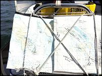
As mentioned before, next page references at the sides make life easier, and for a long voyage they are put on board in the right order. That chart that is of no further use just is put in the jockey. In addition each route is put on A8 (or A7?) wetnotes. The wetnotes have a reference to the chart, and the charts have a reference to the wetnotes for complicated passages. 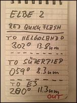
HW and LW times are noted on wetnotes for critical points of the route.
And finally, I have a chartplotter. But in difficult and tight passages the plotter is useful for a quick overview only. The routeplanning needs to be done at shore, a chartplotter in 5.4" format is something of limited use at high speed when bouncing around and with cold hands.
Chinagraph (or cheapest eyeliner) +1, and remember to remove notes from gelcoat asap. Needs lotsa elbow grease later if forgotten.
__________________
|
|
|
|
|
24 September 2012, 21:13
|
#16
|
|
Member
Country: Finland
Town: Helsinki
Boat name: SR 5.4
Make: Avon
Length: 4m +
Engine: Toh1 3,5 Yam 90/2S
Join Date: Oct 2009
Posts: 919
|
Quote:
Originally Posted by Pikey Dave
At high speed I sometimes struggle to see the plotter, never mind a chart
|
Same issue here...especially in little rougher weather. Using paper charts on the SR is no fun, just having them as backup and route planning even if the coastal charts here are available in pretty handy size. But i take as a routine to drop the speed every now and then, counting passengers and double checking position.
__________________
fun on a boat is inversely proportional to size...sort of anyway
|
|
|
|
|
24 September 2012, 21:57
|
#17
|
|
Member
Country: UK - Scotland
Town: Girvan & Tayvallich
Boat name: Breawatch
Make: Ribcraft
Length: 5m +
Engine: Mercury 150 F/stroke
MMSI: ex directory!!
Join Date: Sep 2008
Posts: 6,203
|
I have laminated all the charts for my area and keep them in a ring binder, being laminated there easy to write on. I also carry 'Sailing Instructions' for my area and 'Welcome Anchorages'. I have a plotter and I have 'Fly to Me app on my iphone. But like others on here I do my plan the night before and write down all my important points and tracks on a seperate paper especially if I am going somewhere new.
__________________
jambo
'Carpe Diem'
Member of the ebay Blue RIB cover club
Member of SABS ( Scottish West Division)
|
|
|
|
|
24 September 2012, 22:05
|
#18
|
|
Member
Country: UK - England
Town: London
Length: 4m +
Join Date: May 2011
Posts: 266
|
I have the Imray charts C1 & C2, but they are too big to laminate, do Imray do smaller versions that can be easily laminated?
Essentially what I was trying to work out is what I needed to practice before doing an Advanced Powerboat course.
I already do a passage plan beforehand, but I thought there was some kind of high speed chart plotting exercise on the course, have I imagined that!
__________________
|
|
|
|
|
24 September 2012, 22:21
|
#19
|
|
Member
Country: UK - Scotland
Town: Girvan & Tayvallich
Boat name: Breawatch
Make: Ribcraft
Length: 5m +
Engine: Mercury 150 F/stroke
MMSI: ex directory!!
Join Date: Sep 2008
Posts: 6,203
|
Quote:
Originally Posted by vjmehra
I have the Imray charts C1 & C2, but they are too big to laminate, do Imray do smaller versions that can be easily laminated?
Essentially what I was trying to work out is what I needed to practice before doing an Advanced Powerboat course.
I already do a passage plan beforehand, but I thought there was some kind of high speed chart plotting exercise on the course, have I imagined that!
|
Join My harbour website download using their software and you can zoom in to any location capture and print then laminate, then you will have A4 and you can do them back to back.
__________________
jambo
'Carpe Diem'
Member of the ebay Blue RIB cover club
Member of SABS ( Scottish West Division)
|
|
|
|
|
24 September 2012, 22:24
|
#20
|
|
Member
Country: UK - England
Town: London
Length: 4m +
Join Date: May 2011
Posts: 266
|
Wow, that is quite a cool website, thanks!
__________________
|
|
|
|
|
|
 Posting Rules
|
You may not post new threads
You may not post replies
You may not post attachments
You may not edit your posts
HTML code is Off
|
|
|
|
 Recent Discussions
 |
|
|
|
|
|
|
|
|
|
|
|
|
|
|
|
|
|
|
|
|
|
|
|
|
|
|
|
|
|
|
|
|
|


 BLACK PIG
 Piglet
 Breawatch