|
|
 08 June 2014, 07:31
|
#1
|
|
Member
Country: UK - Scotland
Town: Stirling
Boat name: The Gurnard
Make: Quicksilver
Length: 4m +
Engine: mariner 25hp 2s
Join Date: Jul 2013
Posts: 1,653
|
Small Sibbing round Gigha by The Gurnard
I didnt get out boating this weekend because I was too busy helping my youngest daughter install a kitchen in her house. Besides... it was rather wet and windy on the water.. so dont feel as if I missed anything.
But fear not... as promised in my last journey around the Arisaig area .. I will post one this week on Small Sibbing around the Island of Gigha... an island off the Kintyre Peninsula.
Perhaps you will soon discover why Sir Paul McCartney fell in love with Kintyre, bought his farm at Campbeltown .. and wrote in his hit song Mull of Kintyre about the sea of desire.
This is a retrospective adventure, but it is also a journey which has stuck in my memory as one of my best small SIB experiences yet.
My vessel of choice for this journey was none other than my 14-15 year old, cheap as chips, Chinese made, slat floor 2.7meter plastic Seago SIB. You may knock them, but you cant ignore them, and you can have a bag of fun with them. It cost approx £300 new and has been used every year since.. so has been great value for money at approx £25 per year. Bang for buck..what could be better value ?
However I would not advise a newbie to rush out and buy one, thinking you can then go round the Island of Gigha on it. There is far more to boating than blowing up a bag of air and then going to sea to enjoy the scenery. Think of it like a car ... you cant expect to drive safely around Scotland having never driven before.So saying... when I see some drivers on our roads at present ..I sometimes wonder if it is such a good comparison ?
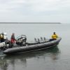
This is my trusty Seago SIB. I would like to say it is very seaworthy.. and I guess it could be as it will not sink... as long as it is inflated.. but it is a very wet boat in a small wave. They have a tendency to come over the low sides.. so at times.. it can be like boating in a paddling pool.
 Even in this size of SIB, I would never consider going to sea without an auxiliary engine. Modern engines can, and do break down. I try to reduce all risks. On this journey..my main engine was a 2.5HP Suzuki four stroke.. and the aux engine was a 2hp Yamaha 2 stroke. The choice of power was for no other reason than... that is all I had available at that time. It means I could only go at slow displacement speeds of around 5 miles per hour. That was not a problem because I was going on this adventure accompanied by my brother and a friend... who were going ... by sea kayak.
 Dont be mistaken and think I was their rescue boat, in truth, it was the reverse. A sea kayak is a very seaworthy boat in experienced hands. In the unlikely event that one is knocked over by a large wave, it can easily be rolled back up with a flip of the paddle, without the occupant getting their feet wet. A spray cover around the cockpit forms an almost waterproof seal. A large wave will wet my feet..and could even wash out my means of propulsion.
Before going round Gigha..I had to make sure there were no strong tides in the area. A 2.5hp outboard couldnt cope with currents of any significance. I checked the admiralty charts of the area and they showed I could cope with the tides in the area with ease.
For anyone who doesnt have charts for Scotland, there are a full set at this link. OK they are almost 300 years old.. but I believe that the main tides and islands wont have changed much over that period.. although smaller stuff like sandbanks etc will..so dont take them as highly accurate.
Admiralty Charts of Scotland, 1795-1904 - Maps of Scotland
To use them ...click the chart you wish to view.. then you can zoom in almost indefinitely to see the detail. Here is a snapshot of Ardminish Bay on the Island of Gigha. Note that the depths on the charts are in fathoms and not feets.
Dont be mistaken and think I was their rescue boat, in truth, it was the reverse. A sea kayak is a very seaworthy boat in experienced hands. In the unlikely event that one is knocked over by a large wave, it can easily be rolled back up with a flip of the paddle, without the occupant getting their feet wet. A spray cover around the cockpit forms an almost waterproof seal. A large wave will wet my feet..and could even wash out my means of propulsion.
Before going round Gigha..I had to make sure there were no strong tides in the area. A 2.5hp outboard couldnt cope with currents of any significance. I checked the admiralty charts of the area and they showed I could cope with the tides in the area with ease.
For anyone who doesnt have charts for Scotland, there are a full set at this link. OK they are almost 300 years old.. but I believe that the main tides and islands wont have changed much over that period.. although smaller stuff like sandbanks etc will..so dont take them as highly accurate.
Admiralty Charts of Scotland, 1795-1904 - Maps of Scotland
To use them ...click the chart you wish to view.. then you can zoom in almost indefinitely to see the detail. Here is a snapshot of Ardminish Bay on the Island of Gigha. Note that the depths on the charts are in fathoms and not feets.
 I also take the OS map for the area Im boating in so I can navigate if the mist comes in. I have most OS maps from my hill walking days so dont want to buy charts too. This is a very small map of my journey.. so you can follow it... once I start telling about it.
 But that will be tomorrow.. as this is only a taster for my journey.
Do come back again if you want to see some of the best sandy beaches in Scotland.......
But that will be tomorrow.. as this is only a taster for my journey.
Do come back again if you want to see some of the best sandy beaches in Scotland.......
__________________
|

|

|
|
08 June 2014, 08:53
|
#2
|
|
Member
Country: UK - England
Boat name: Carpe Diem
Make: Ribeye 650S
Length: 5m +
Engine: Yamaha F150
Join Date: Oct 2012
Posts: 548
|
Great stuff, I am already looking forward to the article tomorrow  ..............................
__________________
|
|
|
|
|
08 June 2014, 12:47
|
#3
|
|
Member
Country: UK - England
Length: 3m +
Join Date: Sep 2008
Posts: 2,762
|
Quote:
Originally Posted by The Gurnard

Before going round Gigha..I had to make sure there were no strong tides in the area. A 2.5hp outboard couldnt cope with currents of any significance. I checked the admiralty charts of the area and they showed I could cope with the tides in the area with ease.
|
Great little island is Gigha and great for a small boat adventure. The 9m ribs probably shoot past it in 3 minutes!
Don't want to seem Mr Moany - but there has to be better ways to navigate than a OS Map which is only accurate above MHWS and a 300 year old chart. More than just sand banks will have changed. There could be new underwater obstructions (wrecks, newly discovered rocks etc), there could be reasons not to anchor (under water cables), there could be new jetties etc which may not always be marked on an OS Map. A SIB hardly needs a jetty but in terms of passage planning a Jetty is an escape route.
Not to mention any navigational marks.
Plus an OS Map will usually highlight certain land objects visible from the sea that can be used for transits etc. The OS Map gives you them all and you may not know if you should be able to see a church from the sea etc.
You can get free electronic access to charts via Navionics website.
Quote:
|
Do come back again if you want to see some of the best sandy beaches in Scotland.......
|
The Scottish Maffia will be on to you. You need to remember the official line is that it rains all the time and is full of midges. Keep showing all these nice scenes and the "Public from Englandshire" will arrive...
__________________
|
|
|
|
|
08 June 2014, 14:12
|
#4
|
|
Member
Country: UK - Scotland
Town: Stirling
Boat name: The Gurnard
Make: Quicksilver
Length: 4m +
Engine: mariner 25hp 2s
Join Date: Jul 2013
Posts: 1,653
|
Many thanks for your comments and feedback Whackywoody and Shinyshoe.. it is appreciated  You are also quite correct Shinyshoe.. there are far better ways to navigate than my way.. especially if you are going round the island, in a fast RIB in 3 minutes.
  Please feel free to post the link to the free charts.. so we can all use them. I had a quick look on the site you referred to but it wanted to download stuff onto my computer ?..is that necessary to view the charts ?
However why fly round Gigha and miss the scenery ? There is plenty open ocean without submerged hazards if you want to go fast. Accidents do happen when boats go fast close inshore...and it can be far worse than hitting submerged rocks ..swimmers wont show on any chart ..regardless the accuracy.
So Relax and enjoy it at 5 miles per hours. To use my car analogy again... drive at a speed dictated by conditions. That way you can see the bottom ..the rocks.. the fish.. the seals and otters. That for me is what boating is about and my eyeball travelling at 5 mph does that better than any electronic wizardry or latest chart topping map.
Would the latest charts help me avoid a rock in this channel. ?
Please feel free to post the link to the free charts.. so we can all use them. I had a quick look on the site you referred to but it wanted to download stuff onto my computer ?..is that necessary to view the charts ?
However why fly round Gigha and miss the scenery ? There is plenty open ocean without submerged hazards if you want to go fast. Accidents do happen when boats go fast close inshore...and it can be far worse than hitting submerged rocks ..swimmers wont show on any chart ..regardless the accuracy.
So Relax and enjoy it at 5 miles per hours. To use my car analogy again... drive at a speed dictated by conditions. That way you can see the bottom ..the rocks.. the fish.. the seals and otters. That for me is what boating is about and my eyeball travelling at 5 mph does that better than any electronic wizardry or latest chart topping map.
Would the latest charts help me avoid a rock in this channel. ?
 As for OS maps.. ..like my Tesco Value Tent and cheap as chips Seago... they fit my bill Admirably... Which is to putter around the rocks and reefs .. close inshore .. off the coastline of Scotland.. in good conditions. Of course there are more expensive options .. for those that want to use them.
__________________
|
|
|
|
|
08 June 2014, 19:18
|
#5
|
|
RIBnet admin team
Country: UK - Scotland
Boat name: imposter
Make: FunYak
Length: 3m +
Engine: Tohatsu 30HP
MMSI: 235089819
Join Date: Sep 2005
Posts: 11,622
|
Gurnard - do you use the yachting pilot books at all? I find them very helpful for picking my way through that part of the world and finding the safe route in/out of places. I'll happily spend as long working out where to go, pouring over OS and charts, as I will executing the plan. Mrs Poly seems confused by this.
__________________
|
|
|
|
|
08 June 2014, 19:44
|
#6
|
|
Member
Country: Ireland
Make: Zodiac Mk I
Length: 3m +
Engine: 15 hp Yam two stroke
Join Date: Feb 2012
Posts: 728
|
__________________
|
|
|
|
|
08 June 2014, 20:52
|
#7
|
|
Member
Country: UK - Scotland
Town: Stirling
Boat name: The Gurnard
Make: Quicksilver
Length: 4m +
Engine: mariner 25hp 2s
Join Date: Jul 2013
Posts: 1,653
|
Hi Poly...I can relate to spending hours pouring over maps ..planning routes..both on land and at sea. I also do that often. In winter I climb the hills of Scotland and in summer..sail the seas.
I have read some of the excellent Clyde Cruising Books in the past. My father had a yacht on the west coast when he was alive..so there was always some sea literature floating about our house.
But I guess Im lucky in that my brother... he is in one of the kayaks on this journey ... is in the process of writing a factual book on sea voyages such as this...detailing tides .. launch points ..places of interest ..etc. He is a regular contributor to one of the major paddling magazines.. and a never ending wealth of knowledge and advice about the Scottish coast. What he doesnt know about it ... he will soon make up.
So if in doubt... I ask him.
I just tag along in his shadow...in that respect.
He is also a good photographer... this is one of his photos ... from a place that I could only dream of taking a SIB
 Thanks for posting the link Boatnomad .. Im obviously a bit out of date with free internet charts .. a few years ago ..the old admiralty ones were the only ones I could find.. so glad to see things have progressed ..
Thanks for reading
Thanks for posting the link Boatnomad .. Im obviously a bit out of date with free internet charts .. a few years ago ..the old admiralty ones were the only ones I could find.. so glad to see things have progressed ..
Thanks for reading 
__________________
|
|
|
|
|
08 June 2014, 20:59
|
#8
|
|
Member
Country: UK - England
Town: Ashton-under-Lyne Lancs
Boat name: IMOGEN
Make: Air-Craft 5.4
Length: 5m +
Engine: Suzuki df70a
MMSI: 235087492
Join Date: May 2010
Posts: 7,078
|
Is that St Kilda ? and your Bro did that in a kayak WOW
__________________
Member of S.A.B.S. (Lancashire Division)
|
|
|
|
|
08 June 2014, 21:18
|
#9
|
|
Member
Country: UK - Scotland
Town: Stirling
Boat name: The Gurnard
Make: Quicksilver
Length: 4m +
Engine: mariner 25hp 2s
Join Date: Jul 2013
Posts: 1,653
|
Yup..its St Kilda..or Stac an Armin to be more exact.
He went as official photographer for a certain commercial venture. The kayaks were taken out by boat.. but it is still something else to paddle around those stacs. Even in the calm the huge swell crashing on cliffs is treacherous.
The photos were something else ... but Im not plugging him.. he does that well enough.

__________________
|
|
|
|
|
08 June 2014, 21:31
|
#10
|
|
Member
Country: UK - England
Town: Ashton-under-Lyne Lancs
Boat name: IMOGEN
Make: Air-Craft 5.4
Length: 5m +
Engine: Suzuki df70a
MMSI: 235087492
Join Date: May 2010
Posts: 7,078
|
You're right it is something else..... you both should do a TV series on your adventures...
"The Gurnard Bros Atlantic ocean Adventures"
I love your posts and I am looking forward to plenty more as I'm sure are a lot of other RIBnet members.
Glad you joined our forum
__________________
Member of S.A.B.S. (Lancashire Division)
|
|
|
|
|
08 June 2014, 21:59
|
#11
|
|
Member
Country: UK - Scotland
Town: Aberdeenshire
Boat name: Sula
Make: Ribcraft 4.8m
Length: 4m +
Engine: Tohatsu 70hp + aux
MMSI: 235087213
Join Date: Jun 2007
Posts: 4,534
|
Recognise the boat in the background. It's the MV Cuma out of Miavaig, Lewis. Sea kayaking at St Kilda is quite an accomplishment. Hat off to your brother.
__________________
Is that with or without VAT?
|
|
|
|
|
09 June 2014, 15:42
|
#12
|
|
Member
Country: UK - Scotland
Town: Stirling
Boat name: The Gurnard
Make: Quicksilver
Length: 4m +
Engine: mariner 25hp 2s
Join Date: Jul 2013
Posts: 1,653
|
Yup Spartacus.. the mother ship was the MV Cuma... and from what I am told.. you couldnt ask for a better host. It certainly was an accomplishment for the guys that did the Kayaking too.
Rock hopping around the base of towering columns of cliff in a swell that could split a kayak in seconds, if a wrong move was made, or in a lapse of concentration.. It undoubtedly takes a lot of skill and nerves of steel... but what an experience.
Its not until you are in such a vast .. and exposed environment ..in a very small boat ... that you get a true feeling of the power and beauty of the sea and our wonderful coastline
 What is even more remarkable.. is my brother was almost 60 years old when he did it and could hardly walk. Due to a genetic problem..his knee caps keep slipping.
Not long after his trip around St Kilda.. we climbed to the top of the Ailsa Craig. He suffered as he climbed.. supported by two walking poles.. but he got to the top..and back again..under his own steam..then paddled the 10 miles of open sea .. back to Lendalfoot.
What is even more remarkable.. is my brother was almost 60 years old when he did it and could hardly walk. Due to a genetic problem..his knee caps keep slipping.
Not long after his trip around St Kilda.. we climbed to the top of the Ailsa Craig. He suffered as he climbed.. supported by two walking poles.. but he got to the top..and back again..under his own steam..then paddled the 10 miles of open sea .. back to Lendalfoot.

 I can only minutely mimic his adventures in a small SIB.. but I go to other extremes and try to do my small boat adventuring on a shoe string. I sometimes strand myself on remote islands.. to survive off the sea..if I can not catch the fish.. I will eat the bait. Eventually I start crapping white like a seagull..
So why do we do such things ?
Perhaps its boredom and we are looking for adventure ... perhaps its because of a deep love of what we are doing and the environment we do it in.. or perhaps its just sheer stupidity ...
But whatever it is that drives us... neither of us would dream of passing by Gigha in three minutes... keep reading and you will find out why.
I can only minutely mimic his adventures in a small SIB.. but I go to other extremes and try to do my small boat adventuring on a shoe string. I sometimes strand myself on remote islands.. to survive off the sea..if I can not catch the fish.. I will eat the bait. Eventually I start crapping white like a seagull..
So why do we do such things ?
Perhaps its boredom and we are looking for adventure ... perhaps its because of a deep love of what we are doing and the environment we do it in.. or perhaps its just sheer stupidity ...
But whatever it is that drives us... neither of us would dream of passing by Gigha in three minutes... keep reading and you will find out why.
__________________
|
|
|
|
|
09 June 2014, 17:47
|
#13
|
|
Member
Country: UK - Scotland
Town: Stirling
Boat name: The Gurnard
Make: Quicksilver
Length: 4m +
Engine: mariner 25hp 2s
Join Date: Jul 2013
Posts: 1,653
|
I guess Im a bit like Ronnie Corbet ..when he starts telling a joke. I am easily distracted too and tend to vary topic.. so to get back on track...  My adventure started in the sleepy village of Tayinloan on the Campbeltown Peninsula.
The beautiful Island of Gigha ... which the locals nickname.. Gods Green Isle ... lies approximately 2.5 miles off shore.
My adventure started in the sleepy village of Tayinloan on the Campbeltown Peninsula.
The beautiful Island of Gigha ... which the locals nickname.. Gods Green Isle ... lies approximately 2.5 miles off shore.
 The beauty of my small Seago SIB is that I could carry it onto this sandy beach beside the pier that the commercial ferry departs from.
The Boat launch site suggests that it is possible to launch from their slipway if the ferry is not at the pier. If anyone can confirm this is correct ... it may help others with somewhere to launch a larger boat ?
The beauty of my small Seago SIB is that I could carry it onto this sandy beach beside the pier that the commercial ferry departs from.
The Boat launch site suggests that it is possible to launch from their slipway if the ferry is not at the pier. If anyone can confirm this is correct ... it may help others with somewhere to launch a larger boat ?
 Its always a good idea to have a plan B ..if something goes wrong.. even on a small boat trip.. so Gigha is ideal as you can always land .... and get the ferry back.
 But do keep well clear of it. The ferry is a business and runs to a timetable. It will get annoyed if you delay it for any reason.
We kept well to the side as it crossed. My brother in the kayak ... is a little camera shy ..so you will see a few photos of the back of his head.
But do keep well clear of it. The ferry is a business and runs to a timetable. It will get annoyed if you delay it for any reason.
We kept well to the side as it crossed. My brother in the kayak ... is a little camera shy ..so you will see a few photos of the back of his head.
 But he has an annoying habit of snapping me while I day dream
 The crossing was calm and relaxing..my wrist doing the work as the others paddled effortlessly
Even with only my now soggy copy of an OS map.. we easily found our way into Ardminish Bay .... to land at the Boathouse ..for an excellent morning coffee and cake.
The crossing was calm and relaxing..my wrist doing the work as the others paddled effortlessly
Even with only my now soggy copy of an OS map.. we easily found our way into Ardminish Bay .... to land at the Boathouse ..for an excellent morning coffee and cake.
 Which we happily devoured sitting outside .. Admiring a scene that could have come from a Mediterranean Advert
 We had to start the day off on the right foot.. after the exposed and tiring crossing of the Sound of Gigha..
to be continued.....
We had to start the day off on the right foot.. after the exposed and tiring crossing of the Sound of Gigha..
to be continued.....
__________________
|
|
|
|
|
09 June 2014, 20:00
|
#14
|
|
Member
Country: UK - England
Length: 3m +
Join Date: Sep 2008
Posts: 2,762
|
Navionics online chart is available at:
WebApp | Navionics
But you might also be interested in:
OpenSeaMap - The free nautical chart although it looks like Gigha hasn't been mapped yet. (Suspect its more the marinas etc that get done.) Certainly DON'T use this for Nav!.
And:
West Coast of Scotland Charts
Which feels a bit like crowd sourced charting (not sure how big the crowd is!) for the W Coast of Scotland and very high detail. They have 3 for Gigha alone! I think it costs about £12 for all their charts. Print em out and laminate?
__________________
|
|
|
|
|
09 June 2014, 20:24
|
#15
|
|
Member
Country: Ireland
Town: Cork
Boat name: Sea Borne
Make: Redbay 750
Length: 7m +
Engine: Suzuki 300 hp O/B
Join Date: Feb 2010
Posts: 90
|
Isle of Gigha
A group of us spent 2 nights on Gigha last year, using it a s base to cruise from , lovely setting had a great time in the Boathouse and The Hotel..Lovely Island.
__________________
"Never say Never because Someday you just might"
|
|
|
|
|
10 June 2014, 15:21
|
#16
|
|
Member
Country: UK - Scotland
Town: Stirling
Boat name: The Gurnard
Make: Quicksilver
Length: 4m +
Engine: mariner 25hp 2s
Join Date: Jul 2013
Posts: 1,653
|
Many Thanks Shinyshoe and Boatnomad for the links to the free charts. They may be of use to others as well as myself. Thanks also to Ribliam for dropping in..it is appreciated.
Revived by our morning coffee at the boathouse, I had a quick look around at the pontoon where larger boats moor and access the island facilities. It was my first visit to Gigha and I was impressed by the peace and quiet.. and also the service of friendly locals.
 Its not so important in a larger boat.. but it helps a kayak or small boats to know which way the tide is flowing .. to assist their journey.. rather than fight against it. As a rule .. (but like every rule, there are exceptions) .. when the tide goes out in this area.. the flow runs in a southern direction. When the tide is coming in.. the flow runs in a northern direction.
As the tide was still going out.. we headed south of Ardminish Bay so the kakays didn’t have to paddle against the tide. Our journey took us through the delightful skerries of Gigha. I let my companions paddle ahead as I switched off the outboard and began a slow drift through the rocks.
Its not so important in a larger boat.. but it helps a kayak or small boats to know which way the tide is flowing .. to assist their journey.. rather than fight against it. As a rule .. (but like every rule, there are exceptions) .. when the tide goes out in this area.. the flow runs in a southern direction. When the tide is coming in.. the flow runs in a northern direction.
As the tide was still going out.. we headed south of Ardminish Bay so the kakays didn’t have to paddle against the tide. Our journey took us through the delightful skerries of Gigha. I let my companions paddle ahead as I switched off the outboard and began a slow drift through the rocks.
 I can think of nothing more relaxing than drifting through the crystal clear shallows of the largest aquarium in the world. The heat of the sun on my back.. the soft sound of the sea slap on the sides of the SIB ... the wonderful undersea views .. and... I was soon drifting away myself....


 The steady flow gently carried my floating viewing platform into deeper water where the tables were turned. The larger sea creatures came to view me.
 As I too turned tables and stole the dinner from under their nose.
 Then landed and cooked the fish before rigor mortise had a chance to set in
 There is nothing that tastes so good as a fresh caught and cooked Mackerel.. Morrison’s Mackerel.. eat your hear out ... it just cant compare.
After this delicious second breakfast, we drifted past the reefs and rocks of Gigalum Island ..on our way to Cara.
There is nothing that tastes so good as a fresh caught and cooked Mackerel.. Morrison’s Mackerel.. eat your hear out ... it just cant compare.
After this delicious second breakfast, we drifted past the reefs and rocks of Gigalum Island ..on our way to Cara.
 Do come back to find out about the beautiful Island of Cara ..and read of its ghostly legend
Thanks for reading this far
Do come back to find out about the beautiful Island of Cara ..and read of its ghostly legend
Thanks for reading this far
__________________
|
|
|
|
|
10 June 2014, 15:53
|
#17
|
|
Member
Country: UK - England
Town: Ashton-under-Lyne Lancs
Boat name: IMOGEN
Make: Air-Craft 5.4
Length: 5m +
Engine: Suzuki df70a
MMSI: 235087492
Join Date: May 2010
Posts: 7,078
|
You are right mate you can't beat the taste of freshly caught mackerel, great pics and report again as usual and I'm looking forward to the ghostly tale of Cara.
__________________
Member of S.A.B.S. (Lancashire Division)
|
|
|
|
|
10 June 2014, 16:07
|
#18
|
|
Member
Country: UK - England
Town: Oop North
Length: 3m +
Join Date: Jul 2013
Posts: 327
|
Cracking photos as usual Gurnard. I should try harder, but there's not much variation in the scenery in the bit of coast I fish. I'm also loathe to take my DSLR out in the boat, so make do with a cheap Aldi waterproof point and click.
Glad you managed to sneak a couple of Mackerel from under Sammy's nose, they look very tasty, just wish I liked fish.
__________________
|
|
|
|
|
11 June 2014, 19:52
|
#19
|
|
Member
Country: UK - Scotland
Town: Stirling
Boat name: The Gurnard
Make: Quicksilver
Length: 4m +
Engine: mariner 25hp 2s
Join Date: Jul 2013
Posts: 1,653
|
We went with the tide down the east landward side of Gigha then crossed the reefs so we were now going down the west seaward side of the island of Cara. If that doesnt make sense...check the OS map I posted in the first page.
 The plan was the tide would still assist us heading south, but although none of the charts showed strong tides in the area, my brother knew it would be a bumpy ride rounding the southern tip of Cara. Even in a calm day.. the tide going round the headland.. meeting the sea breeze blowing in the opposite direction causes a section of confused water.
In my small sib it felt quite choppy so I didnt risk my camera getting wet until I was well round the headland and took this photo. A larger boat probably wouldnt notice it.. but a small boat feels every pothole in the road
The plan was the tide would still assist us heading south, but although none of the charts showed strong tides in the area, my brother knew it would be a bumpy ride rounding the southern tip of Cara. Even in a calm day.. the tide going round the headland.. meeting the sea breeze blowing in the opposite direction causes a section of confused water.
In my small sib it felt quite choppy so I didnt risk my camera getting wet until I was well round the headland and took this photo. A larger boat probably wouldnt notice it.. but a small boat feels every pothole in the road
 My brother knew that if we had approached the confused water by rounding Cara from the other direction, as well as meeting the chop head on, we would be fighting our way through it. As it was.. we were carried quickly through it and soon gained the shelter of the rocky Mull of Cara.
 The Mull of Cara is the Islands highest point and although not high by sea cliff standard.. t still dwarfs the kayaks paddling below.
 After the excitement of the short bumpy ride, and since is felt like ages since our second breakfast, we decided to land on the first sandy beach we found for first lunch.
 I was a little puzzled by the antics of my two kayak companions when they first set foot on Cara.
Both took of their hats, bowed and said Good day Mr Brownie.
When they suggested I did the same.. I asked why.
They told me about the unhappy spirit of a murdered MacDonald who still haunts the island. His ghost is supposed to be around three foot tall and brown in colour. Possibly similar to the green leprechauns of Ireland ? If you dont greet him in the appropriate manner.. he will play all kinds of mischievous pranks on you. My reply was Dont be silly..there is no such thing as ghosts.
We ate our lunch of sandwiches on the sand, then.. when I went back to my SIB..I discovered someone had tampered with the bow. My companions denied all knowledge, saying I had probably upset Mr Brownie.
I was a little puzzled by the antics of my two kayak companions when they first set foot on Cara.
Both took of their hats, bowed and said Good day Mr Brownie.
When they suggested I did the same.. I asked why.
They told me about the unhappy spirit of a murdered MacDonald who still haunts the island. His ghost is supposed to be around three foot tall and brown in colour. Possibly similar to the green leprechauns of Ireland ? If you dont greet him in the appropriate manner.. he will play all kinds of mischievous pranks on you. My reply was Dont be silly..there is no such thing as ghosts.
We ate our lunch of sandwiches on the sand, then.. when I went back to my SIB..I discovered someone had tampered with the bow. My companions denied all knowledge, saying I had probably upset Mr Brownie.
 Still a bit sceptical.. I turned when I heard a strange noise. At first I thought I saw a small brown man..but then he transformed into a feral Goat
 Many remote Scottish Islands are over run with these wild goats. They have no natural predators so flourish in great numbers. However I was glad to get back on the water again.
Passing the only house on Cara.. I was then told of the two friends that once stayed there. One was a MacDonald and the other was a Campbell. An unlikely friendship to begin with..but one night..in a drunken rage..the Campbell murdered the MacDonald in one of the upstairs bedrooms. It is his spirit that is called The Brownie of Cara.
Many remote Scottish Islands are over run with these wild goats. They have no natural predators so flourish in great numbers. However I was glad to get back on the water again.
Passing the only house on Cara.. I was then told of the two friends that once stayed there. One was a MacDonald and the other was a Campbell. An unlikely friendship to begin with..but one night..in a drunken rage..the Campbell murdered the MacDonald in one of the upstairs bedrooms. It is his spirit that is called The Brownie of Cara.
 When I heard this..I wanted to find out more ...... I am a sucker for old legends ... so I just had to land again..
__________________
|
|
|
|
|
11 June 2014, 20:49
|
#20
|
|
Member
Country: UK - Scotland
Town: Stirling
Boat name: The Gurnard
Make: Quicksilver
Length: 4m +
Engine: mariner 25hp 2s
Join Date: Jul 2013
Posts: 1,653
|
We landed on Cara again on a stunning beach on the north of the Island. This time ..even I took my hat of and said Good Afternoon Mr Brownie
I didnt want to take any chances as I was going to explore his haunt.
 One of the things that fascinates me about visiting remote islands.. are the ruins and wrecks abandoned many years ago. They are still as they were left. Not like on the mainland where gipsies would have stolen anything for scrap. My friend plays on an old tractor.
On other islands ..I have seen old iron baths.. stoves.. wooden larders and old beds.. in ruins with no roofs. You can just imagine how their owners lived..especially in cold stormy winter nights.
One of the things that fascinates me about visiting remote islands.. are the ruins and wrecks abandoned many years ago. They are still as they were left. Not like on the mainland where gipsies would have stolen anything for scrap. My friend plays on an old tractor.
On other islands ..I have seen old iron baths.. stoves.. wooden larders and old beds.. in ruins with no roofs. You can just imagine how their owners lived..especially in cold stormy winter nights.
 We went to the house and peered though the windows. It is a holiday home now..so only used in the summer. It looked quite 1950-60 decor and furniture. I imagined the upstairs bedroom where the fight broke out. However ..all was silent when we passed by.
 Perhaps the Brownie was on patrol.. so we decided to walk the length of the island. As we gained a little height the views started to open up
 And got better with every step we took...
 Until we came to a small cairn in the centre of Cara. The purple heather added contrast to the blue sky. The islands of Gigha and Jura in the backdrop, added contrast to the blue sea.
 Then we set of to the south of the island.... I was looking for the Brownies Chair. It is a feature marked on my OS map ..but not on any of the charts I have looked at.. including the ones in the links. I guess OS maps serve their purpose too.. even soggy ones. My friend tried the chair out for size..but he felt a bit uncomfortable sitting on it.
 From the Brownies Chair..its only a short stroll to the top of the Mull of Cara. .. which has a great view over to the Island of Islay
 There was no sign of any Brownie.. ghost or spirit anywhere.. so we returned the way we came.
Just as I was beginning to think to was all just a stupid legend.. we came across a strange wooden shape. Surely .. we would have certainly noticed it when we first passed this way ?
There was no sign of any Brownie.. ghost or spirit anywhere.. so we returned the way we came.
Just as I was beginning to think to was all just a stupid legend.. we came across a strange wooden shape. Surely .. we would have certainly noticed it when we first passed this way ?
 So I confess.. I left Cara a little confused.. but I can assure you ..any time I go back and land on Cara..I take off my hat and say Good Day Mr Brownie Nothing strange has happened since
Tomorrow.. we continue our adventure around Gigha itself ...
So I confess.. I left Cara a little confused.. but I can assure you ..any time I go back and land on Cara..I take off my hat and say Good Day Mr Brownie Nothing strange has happened since
Tomorrow.. we continue our adventure around Gigha itself ...
__________________
|
|
|
|
|
|
 Posting Rules
|
You may not post new threads
You may not post replies
You may not post attachments
You may not edit your posts
HTML code is Off
|
|
|
|
 Recent Discussions
 |
|
|
|
|
|
|
|
|
|
|
|
|
|
|
|
|
|
|
|
|
|
|
|
|
|
|
|
|
|
|
|
|
|


 Imogen
 Sula
Sula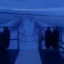 Keamore
 No Name
 Sea Borne