|
 19 September 2021, 14:25
|
#1
|
|
Member
Country: UK - England
Town: Stroud
Boat name: Scud
Make: Ribtec
Length: 5m +
Engine: Twin 40 mariners
Join Date: Sep 2021
Posts: 24
|
Anyone gone from Uig on Skye to Tarbet, outer Hebrides?
Thinking of doing this next summer. Distance? Safe parking for the car and trailer etc? Safe night anchorage on west side on beaches? Fuel requirements, nice beaches to camp on?
__________________
|

|

|
|
19 September 2021, 16:33
|
#2
|
|
Member
Country: UK - Scotland
Make: HumberOceanOffshore
Length: 8m +
Engine: Volvo KAD300/DPX
Join Date: Oct 2002
Posts: 5,596
|
Need more info. Tarbert is about 20 miles from Uig. When you say camping on the west, the west of where? There is a campsite at Uig. You can leave your trailer at Uig, trailers are fairly often left at the side of the ferry car park. There's no security so you take your chance. I've done it a few times with no issue. I dare say you could leave it in the camp site if you pay them.
__________________
JW.
|
|
|
|
|
19 September 2021, 16:36
|
#3
|
|
Member
Country: UK - England
Town: South Yorks
Boat name: Black Pig
Make: Ribcraft
Length: 5m +
Engine: DF140a
MMSI: 235111389
Join Date: Feb 2008
Posts: 11,888
|
Quote:
Originally Posted by Scud

Thinking of doing this next summer. Distance? Safe parking for the car and trailer etc? Safe night anchorage on west side on beaches? Fuel requirements, nice beaches to camp on?
|
Not done that exact run, we did Greshornish to Lochmaddy & then onto St Kilda. You can wild camp in lochmaddy by the ferry pier & theres a pontoon with showers & toilets. Fuel is (was) available In Lochmaddy, but you had to lug it in Jerry cans from the village to the pontoon. We took a collapsible sack trolley for the fuel run. The sound of Harris is stunning in its own right & well deserves exploration.
The Minch can be snotty if you pick the wrong day.
The whole area is glorious in the right weather, & well worth the effort.
__________________
Rule#2: Never argue with an idiot. He'll drag you down to his level & then beat you with experience.
Rule#3: Tha' can't educate pork.
Rule#4: Don't feed the troll
|
|
|
|
|
19 September 2021, 16:38
|
#4
|
|
Member
Country: UK - England
Town: Stroud
Boat name: Scud
Make: Ribtec
Length: 5m +
Engine: Twin 40 mariners
Join Date: Sep 2021
Posts: 24
|
__________________
|
|
|
|
|
19 September 2021, 16:40
|
#5
|
|
Member
Country: UK - England
Town: Stroud
Boat name: Scud
Make: Ribtec
Length: 5m +
Engine: Twin 40 mariners
Join Date: Sep 2021
Posts: 24
|
around here. It would be a 4x4 plus trailer left at Uig. Wild camping on the map.
__________________
|
|
|
|
|
19 September 2021, 16:54
|
#6
|
|
Member
Country: UK - England
Town: Stroud
Boat name: Scud
Make: Ribtec
Length: 5m +
Engine: Twin 40 mariners
Join Date: Sep 2021
Posts: 24
|
Quote:
Originally Posted by Pikey Dave
Not done that exact run, we did Greshornish to Lochmaddy & then onto St Kilda. You can wild camp in lochmaddy by the ferry pier & theres a pontoon with showers & toilets. Fuel is (was) available In Lochmaddy, but you had to lug it in Jerry cans from the village to the pontoon. We took a collapsible sack trolley for the fuel run. The sound of Harris is stunning in its own right & well deserves exploration.
The Minch can be snotty if you pick the wrong day.
The whole area is glorious in the right weather, & well worth the effort.
|
Hi Pikey. How long for journey and at what speed? Training in river Severn and inner Hebrides before attempting this.
__________________
|
|
|
|
|
19 September 2021, 17:02
|
#7
|
|
Member
Country: UK - England
Town: Waterlooville
Boat name: Tickler
Make: Halmatic P22
Length: 6m +
Engine: Inboard Diesel 240HP
MMSI: 235115642
Join Date: Sep 2015
Posts: 1,777
|
Skye doesn't really have much in the way of sandy beaches and the Outer Hebrides tends to be quite fjordy on the east side. You need a way of getting ashore e.g. a little tender.
You could go through the Sound of Harris and then there are a few options sandy beach / anchoring options particularly if you head north - obviously it is weather dependent.
Fuel - I'm not sure there will be petrol available at all at marina's and you'd have to go to the local petrol station. It's not as problematic as it sounds as the locals are (mainly) helpful and friendly and someone's cousin will be able to get fuel for you.
I use a combination of Bing Maps (the satellite imagery has better definition that Google maps), Memory Map, Antares Charts and the Clyde Cruising Club Guide to the Outer Hebrides to do my planning.
__________________
|
|
|
|
|
19 September 2021, 17:07
|
#8
|
|
Member
Country: UK - England
Town: Stroud
Boat name: Scud
Make: Ribtec
Length: 5m +
Engine: Twin 40 mariners
Join Date: Sep 2021
Posts: 24
|
Sounds challenging. Which is fine by me but I’ll have wife 8year olds and collie with me caution is the watch word for this. My rib is 5.35 and has twin 40 two strokes. Internal 50L and two 25L deck tanks. Fuel usage calculations will be done over a week in May.
__________________
|
|
|
|
|
19 September 2021, 17:08
|
#9
|
|
Member
Country: UK - England
Town: South Yorks
Boat name: Black Pig
Make: Ribcraft
Length: 5m +
Engine: DF140a
MMSI: 235111389
Join Date: Feb 2008
Posts: 11,888
|
Quote:
Originally Posted by Scud
Hi Pikey. How long for journey and at what speed? Training in river Severn and inner Hebrides before attempting this.
|
It was around 25nm from Greshornish to Lochmaddy, an hour give or take. If youre venturing into the sound of Harris, you need to study the charts carefully. I had a passage plotted into the GPS through the Cope passage & printed off a set of waypoints & bearings just in case.
__________________
Rule#2: Never argue with an idiot. He'll drag you down to his level & then beat you with experience.
Rule#3: Tha' can't educate pork.
Rule#4: Don't feed the troll
|
|
|
|
|
19 September 2021, 17:11
|
#10
|
|
Member
Country: UK - England
Town: Stroud
Boat name: Scud
Make: Ribtec
Length: 5m +
Engine: Twin 40 mariners
Join Date: Sep 2021
Posts: 24
|
Yes got my eye on a gps plotter for this. Is it rough going through sound of Harris? Looks like the whole of the Atlantic is trying to squeeze through at this place! At high tide best I suspect?
__________________
|
|
|
|
|
19 September 2021, 17:21
|
#11
|
|
Member
Country: UK - England
Town: Waterlooville
Boat name: Tickler
Make: Halmatic P22
Length: 6m +
Engine: Inboard Diesel 240HP
MMSI: 235115642
Join Date: Sep 2015
Posts: 1,777
|
Taransay is a lovely part of the world. Wind strength and direction tend to be the governing factors up there but around the Sound of Taransay, there are a few options should Plan A be scuppered due to an unfavourable wind direction.
__________________
|
|
|
|
|
19 September 2021, 17:54
|
#12
|
|
Member
Country: UK - England
Town: Waterlooville
Boat name: Tickler
Make: Halmatic P22
Length: 6m +
Engine: Inboard Diesel 240HP
MMSI: 235115642
Join Date: Sep 2015
Posts: 1,777
|
Quote:
Originally Posted by Scud
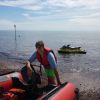
Yes got my eye on a gps plotter for this. Is it rough going through sound of Harris? Looks like the whole of the Atlantic is trying to squeeze through at this place! At high tide best I suspect?
|
It can be horrendous but the attached picture was taken at the northern end of the Sound of Harris in the summer.
Definitely chart plotter territory. I'm sure you could navigate via chart because there are lots of landmarks to take bearings from but a chartplotter removes almost all the stress.
The tidal flows aren't too bad, less than a knot at springs but there are some local bits that are higher than that - between Ensay and Killegray in the Sound of Harris being one of them.
The Cope Channel mentioned by PD is one route out just east of Berneray and Pabbay. Pabbay has some beach anchoring options and a little jetty. The other option is the Stanton Channel which is at the north side of the sound.
I've not much local knowledge so I tend to stick to the bits where I've got water at any tide state. As you come into the beach, you can clearly see the bottom from about 10m in depth out.
As you can tell, I think it's a fantastic neck of the woods for exploring by boat.
__________________
|
|
|
|
|
19 September 2021, 18:56
|
#13
|
|
Member
Country: UK - Scotland
Town: Isle of Lewis
Boat name: Sarah Saunders
Make: XS Ribs
Length: 6m +
Join Date: Dec 2019
Posts: 31
|
Sound of Harris is well buoyed though a gps would be of great benefit, as would doing your day skipper theory course. Decent camping beach to the east of the Isle of Scarp, on the Harris mainland, and on east coast of Mealasta island, both within around 15 miles north of Taransay. Worth remembering that once you round south Harris you are facing the Atlantic and the seas can be quite daunting. Needless to say that landing on a beach with any surf can easily go wrong so be prepared to anchor off and swim in. You mention Tarbert on Harris as your first port of call. They've new pontoons there and the round trip to Harris Garage for fuel is about 0.5 miles. Better give them a phone to check if fuel is still going to be available as they were not operating when I was down last. Otherwise its 5 mile round trip to Ardhasaig by taxi. Also worth pointing out its nearly 40 miles from Tarbert to Taransay so you might want to factor in 40 out, 40 back and 40 miles reserve fuel.
PS mind your Collie :-). Even the uninhabited islands up here are croftland and sheep are ferried out to them for grazing so you will need to keep an eye even if it's a working dog.
ATB
__________________
|
|
|
|
|
19 September 2021, 20:27
|
#14
|
|
Member
Country: UK - Scotland
Make: HumberOceanOffshore
Length: 8m +
Engine: Volvo KAD300/DPX
Join Date: Oct 2002
Posts: 5,596
|
If you're widening your choices to include the areas around and through the Sound of Harris you'll find a number of secluded wee anchorages, many with nice sandy beaches. However, the islands kinda have a climate of their own and you need to be prepared for pretty quick shifts in the weather especially the winds. You could be anchored in the lee of an island to find your boat in a full blast in the morning. Your anchor needs to be secure since you're not going to be onboard.
However, passing through the Sound of Harris is no big deal, it is ok buoyed but it used to be better. I passed through yesterday and there's a pic below of the Cope Passage route. Not all the buoys exist now but my charts still have them displayed. I'm sure if you compare the picture to your charts you'll manage to reference the area. There is one more buoy to the north of the picture which is not shown. It's pretty much in line with the track before it turns off left at the north end then you're free of the sound. The left turn to the track at the north end will take you to Berneray harbour. Just out of the sound be aware of drying rocks off the north corner of Berneray.
__________________
JW.
|
|
|
|
|
20 September 2021, 10:23
|
#15
|
|
Member
Country: UK - England
Town: Stroud
Boat name: Scud
Make: Ribtec
Length: 5m +
Engine: Twin 40 mariners
Join Date: Sep 2021
Posts: 24
|
Thank you.
__________________
|
|
|
|
|
22 September 2021, 07:36
|
#16
|
|
Member
Country: UK - Scotland
Town: North Uist
Boat name: Hebdiver
Make: Rebtec
Length: 5m +
Engine: Tonhatsu 90 tdli
Join Date: Apr 2014
Posts: 48
|
Friend of mine has his rib on the pontoons at Lochmaddy and is known to pop over to Skye , sometimes to the pub at waternish. As Pikey Dave said, whilst the main channel of the sound of Harris is well buoyed it’s very shallow with lots of rocks, you only have to look at the route the small ferry has to take to see that. If you make land fall a little early on the North Uist side , be careful coming through the smaller islands Sursey etc, the White House channel, there are a few uncharted rocks about, a dive rib I sent out there a few years ago lost a skeg and rubbing strip on one such, even after being warned.
It’s wonderful area to explore, with lots of nooks and crannies I have dived out there a few times.
__________________
|
|
|
|
|
 Posting Rules
|
You may not post new threads
You may not post replies
You may not post attachments
You may not edit your posts
HTML code is Off
|
|
|
|
 Recent Discussions
 |
|
|
|
|
|
|
|
|
|
|
|
|
|
|
|
|
|
|
|
|
|
|
|
|
|
|
|
|
|
|
|
|
|


 BLACK PIG
 Piglet
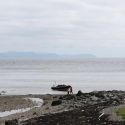 Tickler