|
|
 08 February 2020, 08:42
|
#1
|
|
Member
Country: UK - England
Town: Malmesbury
Boat name: Wheres Dorris
Make: OCEAN
Length: 6m +
Engine: EVINRUDE ETEC 150 G1
Join Date: Nov 2007
Posts: 127
|
Tablet based electronics
I'm sitting inside using google to look up everything I can't afford and definitely don't need for my Ocean 6.25 project, and started thinking (daydreaming really) about what electronics I would do it I was starting over.
A friend of mine with a sailboat has recently faced the challenge of old wiring, dead GPS unit and tired and intermittently faulty wind instruments. He replaced the old systems with a tablet and wifi driven solution bringing everything except engine data onto the device. He now has a handheld GPS plotter and paper charts as the backup, and uses the tablet solution as his primary nav source.
has anyone made the switch and what do you think are the benefits/pitfalls?
__________________
One day it will be mine. Oh yes, it will be mine
|

|

|
|
08 February 2020, 19:47
|
#2
|
|
Member
Country: UK - England
Town: Wild West
Boat name: No Boat
Make: No Boat
Length: under 3m
Join Date: Jan 2008
Posts: 5,304
|
Quote:
Originally Posted by Takson

I'm sitting inside using google to look up everything I can't afford and definitely don't need for my Ocean 6.25 project, and started thinking (daydreaming really) about what electronics I would do it I was starting over.
A friend of mine with a sailboat has recently faced the challenge of old wiring, dead GPS unit and tired and intermittently faulty wind instruments. He replaced the old systems with a tablet and wifi driven solution bringing everything except engine data onto the device. He now has a handheld GPS plotter and paper charts as the backup, and uses the tablet solution as his primary nav source.
has anyone made the switch and what do you think are the benefits/pitfalls?
|
 .Really ....On a RIB?

By the way I'd suggest...you're "friend" gets his hand in his pocket and pays for a proper re-wire and whatever kit needs replacing if the wiring is Shot it's Shot ....the Open Sea is not a place to compromise on safety equipment...or any other electrical system.
__________________
A clever Man learns by his mistakes..
A Wise Man learns by other people's!
The Road to HELL ..is Paved with "Good inventions!"
|
|
|
|
|
09 February 2020, 06:39
|
#3
|
|
Member
Country: France
Town: Côte d'Azur
Boat name: Beaver Patrol
Make: Avon Searider SR4
Length: 4m +
Join Date: Jan 2004
Posts: 5,934
|
Tablet based electronics
I frequently use Navionics on my iPad in all sorts of situations, including on RIBs. iPad lives in a waterproof Lifeproof case (which is fully waterproof - I dropped it in a swimming pool once and it lived to tell the tale).
I wouldnt recommend it as your sole means of navigating - of course you always want as many independent means of navigating as possible. But an iPad or similar is certainly a useful and viable part of that. There are some good cases and mounts out there. One down side is the touch screen doesnt work when its wet.
__________________
|
|
|
|
|
09 February 2020, 07:51
|
#4
|
|
Member
Country: UK - Scotland
Town: north ayrshire
Boat name: charlie girl
Make: S/R5.4/regal3760
Length: 10m +
Engine: Suzukidf70 2x6lp 315
Join Date: Jul 2009
Posts: 3,747
|
Quote:
Originally Posted by Maximus
.Really ....On a RIB?
By the way I'd suggest...you're "friend" gets his hand in his pocket and pays for a proper re-wire and whatever kit needs replacing if the wiring is Shot it's Shot ....the Open Sea is not a place to compromise on safety equipment...or any other electrical system. |
I agree with this sentiment when new plotters are so cheap why bother with a compromise
__________________
|
|
|
|
|
09 February 2020, 08:08
|
#5
|
|
Member
Country: UK - England
Length: 7m +
Join Date: Aug 2009
Posts: 1,619
|
I would tend to agree with the others, tablets are not great on a boat and how will that work when your in an area with no mobile signal which there are plenty of. Handheld unit again not great for viewing and if your in fog which can suddenly arise without warning then perhaps more issues and difficult referring to a psoiton and chart when your in it so to speak.
My advice would be plan to upgrade, if money is short then just buy a second hand plotter and antannee, plenty around on ebay etc, does not need to be a huge screen etc. Make sure wiring is decent and just install a second hand unit as a temp measure and save up for that special present.
__________________
|
|
|
|
|
09 February 2020, 08:53
|
#6
|
|
RIBnet supporter
Country: UK - Isle of Man
Town: Peel, IOM
Length: no boat
Join Date: Nov 2000
Posts: 2,511
|
Or, better still, buy one off craig_c.
__________________
Brian
"Ribbing-the most expensive way of travelling third class"
|
|
|
|
|
09 February 2020, 09:05
|
#7
|
|
Member
Country: UK - England
Town: Malmesbury
Boat name: Wheres Dorris
Make: OCEAN
Length: 6m +
Engine: EVINRUDE ETEC 150 G1
Join Date: Nov 2007
Posts: 127
|
Thanks for the insights.
The boat has come with a Lowrance fish finder and 2 Garmin GPS units so Im not needing to buy anything for this project, it is just out of interest while I browsing around. For example, I find I use the maps on my phone more than the one in the car because solutions like Waze and google maps have constantly updated maps and info, where as the dvd based maps of the car system are out of date and the traffic rerouting capability is pretty poor.
With the likes of Nasa, B&G and Garmin now investing time and money into wireless solutions I wondered if the same was true.
__________________
One day it will be mine. Oh yes, it will be mine
|
|
|
|
|
09 February 2020, 10:29
|
#8
|
|
Member
Country: UK - Scotland
Town: Inverkip
Boat name: Crusader
Make: Redbay 8.4 Exped
Length: 8m +
Engine: yamaha sterndrive
Join Date: Nov 2004
Posts: 755
|
I think you guys might find my little £50 project interesting.
Its purely for investigative purposes and a bit of a hobby and I have an E120 to do all my navigation however I think decent stuff is available for not much cash
https://www.rib.net/forum/f8/chartpl...0-a-83030.html
__________________
2006 Redbay 8.4 Expedition "Crusader"
|
|
|
|
|
09 February 2020, 16:48
|
#9
|
|
Member
Country: UK - England
Town: Malmesbury
Boat name: Wheres Dorris
Make: OCEAN
Length: 6m +
Engine: EVINRUDE ETEC 150 G1
Join Date: Nov 2007
Posts: 127
|
Quote:
Originally Posted by Tim M
I frequently use Navionics on my iPad in all sorts of situations, including on RIBs. iPad lives in a waterproof Lifeproof case (which is fully waterproof - I dropped it in a swimming pool once and it lived to tell the tale).
I wouldnt recommend it as your sole means of navigating - of course you always want as many independent means of navigating as possible. But an iPad or similar is certainly a useful and viable part of that. There are some good cases and mounts out there. One down side is the touch screen doesnt work when its wet.
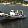
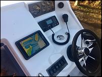
Attachment 132100 |
That looks a nice clean and tidy layout you have there[emoji106]
__________________
One day it will be mine. Oh yes, it will be mine
|
|
|
|
|
09 February 2020, 19:28
|
#10
|
|
Member
Country: UK - Scotland
Town: Denny
Boat name: Highland Bluewater
Length: 6m +
Join Date: Mar 2013
Posts: 1,647
|
I use to run with a "Panasonic toughbook" running CPM86 and Antares as my main nav platform and an old Lowrance as a backup.
Worked well, the Antares charts are cheap and way better than anything from the mainstream suppliers but the toughbook, waterproof as it is, was starting to get corrosion issues but it's biggest downfall was the display. Just not bright enough to be read in bright sunshine.
__________________
|
|
|
|
|
11 February 2020, 22:19
|
#11
|
|
Member
Country: UK - Wales
Town: Cardiff
Length: no boat
Join Date: Aug 2014
Posts: 2,018
|
Quote:
Originally Posted by Last Tango
I use to run with a "Panasonic toughbook" running CPM86 and Antares as my main nav platform and an old Lowrance as a backup.
Worked well, the Antares charts are cheap and way better than anything from the mainstream suppliers but the toughbook, waterproof as it is, was starting to get corrosion issues but it's biggest downfall was the display. Just not bright enough to be read in bright sunshine.
|
There are newer tablets ruggised like the tough book and others ideally oiled displays will be along soon and this will be a big leap in sun light readable tech.
A friend works for a company that makes tablets for military use and pass all the MIL spec drop and ingress tests. But they arent cheap.... but look at the new automotive diagnostic tablets and things and I dont think a suitable device will be far way with better wireless protocols and inductive charging a properly sealed unit is more realistic than ever before and the protocols to get all the data you would ever need from engines sensors satellites etc all exists more and more vessels are coming fitted with touch screens from the factory (like cars) question is will the traditional aftermarket keep up?
Are we on the verge of boat play and android nautical
__________________
|
|
|
|
|
12 February 2020, 07:21
|
#12
|
|
Member
Country: UK - Scotland
Town: north ayrshire
Boat name: charlie girl
Make: S/R5.4/regal3760
Length: 10m +
Engine: Suzukidf70 2x6lp 315
Join Date: Jul 2009
Posts: 3,747
|
Quote:
Originally Posted by HDAV
There are newer tablets ruggised like the tough book and others ideally oiled displays will be along soon and this will be a big leap in sun light readable tech.
A friend works for a company that makes tablets for military use and pass all the MIL spec drop and ingress tests. But they arent cheap.... but look at the new automotive diagnostic tablets and things and I dont think a suitable device will be far way with better wireless protocols and inductive charging a properly sealed unit is more realistic than ever before and the protocols to get all the data you would ever need from engines sensors satellites etc all exists more and more vessels are coming fitted with touch screens from the factory (like cars) question is will the traditional aftermarket keep up?
Are we on the verge of boat play and android nautical
|
Isnt everything in this wish list included in a dedicated plotter? (with the exception of oil filling) doesnt this whole post just reinforce the case for using the right tool for the job instead of trying to adapt something else to use
__________________
|
|
|
|
|
12 February 2020, 10:02
|
#13
|
|
Member
Country: UK - Scotland
Town: Denny
Boat name: Highland Bluewater
Length: 6m +
Join Date: Mar 2013
Posts: 1,647
|
Quote:
Originally Posted by beamishken
Isnt everything in this wish list included in a dedicated plotter? (with the exception of oil filling) doesnt this whole post just reinforce the case for using the right tool for the job instead of trying to adapt something else to use
|
Well no.
the thing I would like is much better charts that didn't cost £170.
I had that on the Tough Book but now I tied to Navionics Gold and Garmin's
rather poor offerings.
Antares costs about £15 and is more valuable than either. 
__________________
|
|
|
|
|
12 February 2020, 12:15
|
#14
|
|
Member
Country: UK - Scotland
Town: north ayrshire
Boat name: charlie girl
Make: S/R5.4/regal3760
Length: 10m +
Engine: Suzukidf70 2x6lp 315
Join Date: Jul 2009
Posts: 3,747
|
Quote:
Originally Posted by Last Tango
Well no.
the thing I would like is much better charts that didn't cost £170.
I had that on the Tough Book but now I tied to Navionics Gold and Garmin's
rather poor offerings.
Antares costs about £15 and is more valuable than either. |
I bought a copy full spec Garmin chart for under £30 which gives me the whole uk & is more than adequate for general navigation. Last time I looked at antares charts they were great for picking a spot to anchor when you got to your destination but no good for general navigation as large areas were uncharted.
__________________
|
|
|
|
|
12 February 2020, 12:40
|
#15
|
|
Member
Country: UK - England
Make: Zodiac
Length: under 3m
Engine: Scull
Join Date: Dec 2014
Posts: 529
|
Quote:
Originally Posted by Last Tango
Well no.
the thing I would like is much better charts that didn't cost £170.
I had that on the Tough Book but now I tied to Navionics Gold and Garmin's
rather poor offerings.
Antares costs about £15 and is more valuable than either. |
Quote:
Originally Posted by beamishken
I bought a copy full spec Garmin chart for under £30 which gives me the whole uk & is more than adequate for general navigation. Last time I looked at antares charts they were great for picking a spot to anchor when you got to your destination but no good for general navigation as large areas were uncharted.
|
I currently use Navionics gold and thinks its great software - and as pointed out already in this thread, tablets etc in sunlight are next to useless 
__________________
|
|
|
|
|
12 February 2020, 14:27
|
#16
|
|
Member
Country: UK - Scotland
Town: Glasgow
Make: Excel Vanguard 395
Length: 4m +
Engine: Suzuki 20
Join Date: Jan 2012
Posts: 79
|
Garmin new charts have navionics updates on them FYI.
__________________
|
|
|
|
|
12 February 2020, 14:48
|
#17
|
|
Member
Country: UK - Scotland
Town: Denny
Boat name: Highland Bluewater
Length: 6m +
Join Date: Mar 2013
Posts: 1,647
|
Quote:
Originally Posted by Fender
I currently use Navionics gold and thinks its great software - and as pointed out already in this thread, tablets etc in sunlight are next to useless |
Not an advocate of tablets either. Personally I don't like touch screens.
My argument would be for a generic plotter that could use multiple charting software.
Taken in isolation Navionics Gold looks ok but for this area Antares provides far more detail for harbours, anchorages and narrow/shallow channels. My beef is with the "closed-shop" regime the plotter manufacturer run to stop us using charts other than the ones they have financial control over. 
__________________
|
|
|
|
|
12 February 2020, 16:45
|
#18
|
|
Member
Country: UK - Scotland
Town: Dunfrmline
Boat name: Black Jem
Make: Ocean Pro 6.3
Length: 6m +
Engine: Suzuki DF140
Join Date: Jan 2020
Posts: 39
|
I'm new to the forum, had loads of questions and have managed to find most of the answers already, so many thanks.
I bought a rib the tail end of last year, and whilst I'm already thinking of going a bit bigger, I'm looking at mods I'd like as I'll probably keep the boat for this season at least.
I've been looking into just this subject over the past couple of days. My boat has a Mariner 60 EFI with just the basic RPM and trim gauges. I was looking at having more engine info, either fed into the fitted Garmin 451s or standalone gauges but was put off with the cost of both. I've just bought a vessel view mobile so I can get the engine data to my phone. But now I'm thinking i could use a tablet on board for Navionics charts and engine data, keeping the Garmin as a depth sounder and back up plotter. I have the same software on phone and tablet so have an extra back up. My phone and old phone are both IP68 rate(I've tested this) so apart from screen not working quite so well when damp water should not been an issue. As for screen brightness, whilst I agree that mobile devices might not be as bright as that of a plotter, I use both my phone and plotter for Skydemon navigation when I'm flying in an open cockpit(my other hobby) and have never had a problem with brightness.
__________________
|
|
|
|
|
12 February 2020, 16:48
|
#19
|
|
Member
Country: UK - Scotland
Town: north ayrshire
Boat name: charlie girl
Make: S/R5.4/regal3760
Length: 10m +
Engine: Suzukidf70 2x6lp 315
Join Date: Jul 2009
Posts: 3,747
|
Quote:
Originally Posted by Last Tango
Not an advocate of tablets either. Personally I don't like touch screens.
My argument would be for a generic plotter that could use multiple charting software.
Taken in isolation Navionics Gold looks ok but for this area Antares provides far more detail for harbours, anchorages and narrow/shallow channels. My beef is with the "closed-shop" regime the plotter manufacturer run to stop us using charts other than the ones they have financial control over. |
How can you use antares for navigation unless you operate in a relatively small area? there are huge patches un charted. Fine for pinpointing your anchor spot but not realy suitable for general navigation.
More novelty value than practical use & then limited to some of Scotland
I certainly couldn't use them alone.
__________________
|
|
|
|
|
12 February 2020, 21:10
|
#20
|
|
Member
Country: UK - Scotland
Town: Denny
Boat name: Highland Bluewater
Length: 6m +
Join Date: Mar 2013
Posts: 1,647
|
Quote:
Originally Posted by beamishken
How can you use antares for navigation unless you operate in a relatively small area? there are huge patches un charted. Fine for pinpointing your anchor spot but not realy suitable for general navigation.
More novelty value than practical use & then limited to some of Scotland
I certainly couldn't use them alone.
|
Never used them on their own. Used in conjunction with Open CPN and Navionics on the Lawrance all well adequate for point to point navigation or "marina hoping".
There was, at last count, over 500 anchorages/harbours covered in detail with Antares and in reality most locations you might head for on the west of Scotland is likely to be covered. In terms of operating in a small area, it's relative, I would rarely do more than 150mls in a day but even at that we've been to every populated island off the west coast of Scotland except Barra and visiting places like Loch Teacuis and the head of Loch Hourn was a lot easier with Antares.
As I said, I wouldn't advocate using a tablet or laptop as a substitute for a plotter but there is no technical reason that a plotter couldn't run third-party charts as well eg. inland lochs. (Navionic's Loch Lomond is very basic and I don't think the Garmin recognises it at all.)
For some reason they allow additional charts to be loaded on handheld plotters but not fixed ones so this isn't a technical issue.
__________________
|
|
|
|
|
|
 Posting Rules
|
You may not post new threads
You may not post replies
You may not post attachments
You may not edit your posts
HTML code is Off
|
|
|
|
 Recent Discussions
 |
|
|
|
|
|
|
|
|
|
|
|
|
|
|
|
|
|
|
|
|
|
|
|
|
|
|
|
|
|
|
|
|
|


 RIB Saffron
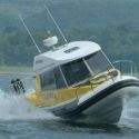 Crusader