Go Back   RIBnet Forums > RIB talk > Electrics and electronics
Click Here to Login

Reply
 
Thread Tools Search this Thread
 
Old 07 January 2012, 16:43   #1
RIBnet supporter
 
Copinsay's Avatar
 
Country: UK - Scotland
Town: Orkney
Boat name: Skylark
Make: Bombard 500
Length: 5m +
Engine: 60hp Yamaha outboard
MMSI: 235091893
Join Date: Jan 2012
Posts: 416
Advice - best electronic chart options for chart plotter - North of Scotland / Orkney

Hello

I understand there can be quite some variability in the quality of charts supplied with chartplotters, and I'd welcome people's experiences / views for Northern Scotland/Orkney.

In particular, we have some detailed localised paper charts for harbour approaches at around 1:25,000 (eg charts 35 Scapa Flow and 2584 Kirkwall) and so I'm seeking the same level of detail.

I've looked at other threads and some people seem to decide about getting the "best" chart plotter and then buy in extra maps; others look for the chart plotter with the best charts as part of the package.

So - what would people recommend? While as ever I'm keen on price, accuracy of the charts, and durability/robustness of the chart plotter on a RIB are of paramount importance. I'm also keen on being able to route plan on the PC etc.

Many thanks for your help

Steve
__________________
Copinsay is offline   Reply With Quote
Old 10 January 2012, 15:51   #2
RIBnet supporter
 
Brian's Avatar
 
Country: UK - Isle of Man
Town: Peel, IOM
Length: no boat
Join Date: Nov 2000
Posts: 2,511
RIBase
I see no-one has replied to your post !
Disgraceful.. Come on you lot!

My experience would not suit you. I use Raymarine E120 with one Navionics chip which gives the whole of the UK but in fine detail. And tend to use Navplanner or Raymarine RNS for preplanning on the computer. But the cost............!!!!!!

From the generalsied recommendations on here I would suggest:
a Garmin plotter
get one as large as you can manage/afford
get a colour one
any charts will be as accurate as you need them and make sure they are up to date and that you regularly have them updated (every couple of years or so)
__________________
Brian is offline   Reply With Quote
Old 10 January 2012, 16:41   #3
Member
 
Pikey Dave's Avatar
 
Country: UK - England
Town: South Yorks
Boat name: Black Pig
Make: Ribcraft
Length: 5m +
Engine: DF140a
MMSI: 235111389
Join Date: Feb 2008
Posts: 11,883
RIBase
IMO Navionics are the best charts, I'm not impressed with what I've seen of Garmin Bluecharts. The Navionics chart of the whole UK was iirc under 200 quid & just like looking at an Admiralty paper chart, and some. The zoom levels & detail are excellent.
__________________
Rule#2: Never argue with an idiot. He'll drag you down to his level & then beat you with experience.
Rule#3: Tha' can't educate pork.
Rule#4:Don't feed the troll
Pikey Dave is offline   Reply With Quote
Old 10 January 2012, 19:32   #4
Member
 
Country: UK - England
Town: Margate / Ramsgate
Boat name: Bumbl
Make: Scorpion
Length: 8m +
Engine: Yanmar diesel
Join Date: Feb 2002
Posts: 2,837
The Navionics are indeed better in detial than the Garmin offering, and thus given what you want from your plotter I would say NOT Garmin.

Cost no object? Go Raymarine. The new e7 is a good price if you cant stretch to the C90W or C120W, although I'm unconvinced about touchscreens on RIBS.

Simrad is another alternative that I dont see enough of as they make a really nice product, a wee bit cheaper than Raymarine. Their rival to the e7 is the NSS7 7" hybrid touch but you still get buttons too.

Certianly the simrad only comes with "bronze" charts, I am not sure off the top of my head if you get more detial from the "silver" or "gold" versions, need to check. Also worth checking what "level" Raymarine supply included in the price.

Both plotters RRP less than £1500. edit: boat show pricing for Simrad NSS7 £999 incl !!, but I just re-read YOUR post and not so sure you're looking for a £1000 plotter, as I happen to be :-(
__________________
Daniel is offline   Reply With Quote
Old 10 January 2012, 22:46   #5
RIBnet supporter
 
Copinsay's Avatar
 
Country: UK - Scotland
Town: Orkney
Boat name: Skylark
Make: Bombard 500
Length: 5m +
Engine: 60hp Yamaha outboard
MMSI: 235091893
Join Date: Jan 2012
Posts: 416
Hello All

Many thanks for your comments... Much appreciated :O)

I did think it was a tad quiet on responses and maybe I'd committed some dreadful faux pas! Glad I haven't....

Amazingly - I coincidentally have a work meeting in London on Friday, and as the Boat Show has a 9pm finish the day before (and cheaper entry after 4pm more to the point!), I'm going to pop along Thursday evening, as I think that will be a good opportunity to compare.

With all the sea we have up here, Orkney and Highlands is all I'll be after for quite a while, as amazing as it is to have all the UK on one chip... But not sure if I can be that selective...?

Any other comments/suggestions welcome.

Best wishes and thanks again.

Steve
__________________
Copinsay is offline   Reply With Quote
Old 11 January 2012, 07:24   #6
Member
 
Pikey Dave's Avatar
 
Country: UK - England
Town: South Yorks
Boat name: Black Pig
Make: Ribcraft
Length: 5m +
Engine: DF140a
MMSI: 235111389
Join Date: Feb 2008
Posts: 11,883
RIBase
AFAIK with Navionics, you get the whole of the UK & Ireland + north coast of France. They used to sell individual areas in the days before large storage cards, now they just stick the whole lot on one card & Robert's your mothers brother. I don't think you can choose your areas anymore. The UK gold chart is cheaper than the individual areas used to be.
__________________
Rule#2: Never argue with an idiot. He'll drag you down to his level & then beat you with experience.
Rule#3: Tha' can't educate pork.
Rule#4:Don't feed the troll
Pikey Dave is offline   Reply With Quote
Old 15 January 2012, 17:42   #7
Member
 
Country: UK - Scotland
Town: Inverness
Boat name: none
Make: none
Engine: none
MMSI: none
Join Date: Mar 2007
Posts: 1,908
Navionics, they are also accurate enough that I don't mind zooming around Orkney based on what they are telling me.
I have been as far north as North Ronaldsay several times via a nyumber of routes and the plotter is telling me the same as the sounder at all times.
Plus the one card does the whole of the country!
__________________
BruceB is offline   Reply With Quote
Old 15 January 2012, 18:12   #8
Member
 
NWC100's Avatar
 
Country: UK - England
Make: Zodiac
Length: 3m +
Engine: 9.9 Hosses!
Join Date: Aug 2011
Posts: 47
A little off topic but might be worth a look, I have the Navionics map of uk and Holland in my android phone, IIRC it cost about £18 to download and is stored on phone, I know this isnt what you are looking for but might be a good way to look at the maps before spending out the money, Im not sure quite how they compare to the ones a plotter...but might be worth a look....Its a possibility they do it for other phones as well....I have no idea ;-)

Nick
__________________
NWC100 is offline   Reply With Quote
Old 15 January 2012, 18:46   #9
RIBnet supporter
 
Copinsay's Avatar
 
Country: UK - Scotland
Town: Orkney
Boat name: Skylark
Make: Bombard 500
Length: 5m +
Engine: 60hp Yamaha outboard
MMSI: 235091893
Join Date: Jan 2012
Posts: 416
Hello All

Many thanks for your comments - really helpful.

Was very useful looking around at the London boat show, as I could play with and compare the various chart plotters and see the displays and map detail.

While the phone or PC option is doubtless cheaper, I really feel having a unit on the boat is really what's needed given the likely spray etc.

From looking at them all, I was most taken with the Garmin units, and there seemed to be a feeling on the stands selling many different makes that these were the most robust... But I welcome other experiences on this.

The Garmin units currently come with the UK g2 charts preloaded, which look to be as good as the paper admiralty charts I'm used to - what do others think... Better or worse than Navionics?

For now I'm seriously considering the 551 or 556... and Homeport software. Any experiences good or bad on those. I have a separate fish finder fitted, and like the idea of that being independent, so I can use the full screen on the 'plotter for navigation.

Best wishes and thanks again.

Steve
__________________
Copinsay is offline   Reply With Quote
Old 03 April 2012, 11:13   #10
RIBnet supporter
 
Copinsay's Avatar
 
Country: UK - Scotland
Town: Orkney
Boat name: Skylark
Make: Bombard 500
Length: 5m +
Engine: 60hp Yamaha outboard
MMSI: 235091893
Join Date: Jan 2012
Posts: 416
.....
__________________
Copinsay is offline   Reply With Quote
Old 09 April 2012, 07:19   #11
Member
 
Country: UK - England
Town: Oxford
Boat name: Polar Star
Make: XS Ribs
Length: 6m +
Engine: 2 x 60hp Mercury
Join Date: Sep 2011
Posts: 11
Hi Copinsay. I use a Garmin wih g2 vision around Eribol and the Kyle of Tongue. I chose Garmin when I went to a boat show and zoomed all of the available GPS units into the bay at Talmine to see which ones gave me the best detail. The Garmin had all the rocks - and danger lines - in the right places, so I got it. The home port software is great for planning routes to upload. I would never dream of entering waypoint-by-waypoint into the unit manually. Mine is an old 451 which has taken years of exposure to the elements. The choice is yours, but for what its worth, I have found the Garmin both accurate and robust for at least SIBing use on the North coast.
__________________
amsuther is offline   Reply With Quote
Old 03 May 2012, 15:05   #12
RIBnet supporter
 
Copinsay's Avatar
 
Country: UK - Scotland
Town: Orkney
Boat name: Skylark
Make: Bombard 500
Length: 5m +
Engine: 60hp Yamaha outboard
MMSI: 235091893
Join Date: Jan 2012
Posts: 416
Hello All

And finally, for those readers in the same position as I was when I posted this, and wondering what to buy, I now have the Garmin 451S and very happy with it.

While I'm sure the bigger screens etc can be helpful, this size and resolution is more than adequate for what I want, especially given the demands of buying other stuff too.

So thanks for all your help

Best wishes

Steve
__________________
Copinsay is offline   Reply With Quote
Old 29 June 2012, 07:32   #13
Member
 
Country: UK - Scotland
Town: orkney
Boat name: Quickstep
Make: Carson
Length: 7m +
Engine: Inboard V8 volvo
Join Date: Jun 2012
Posts: 59
Hi,
(my first post)
I just got a standard horizon 180i for around north orkney and I like it to an extent but thinking of upgrading to a garmin. I think they are more rugged. I guess you find the detail on the garmin satisfactory? I was looking at the 750?
Cheers
Dan
__________________
Danork is offline   Reply With Quote
Old 22 July 2012, 12:22   #14
RIBnet supporter
 
Copinsay's Avatar
 
Country: UK - Scotland
Town: Orkney
Boat name: Skylark
Make: Bombard 500
Length: 5m +
Engine: 60hp Yamaha outboard
MMSI: 235091893
Join Date: Jan 2012
Posts: 416
Charts and other tips for Orkney

Hello Dan

Good to hear from you and apologies for the delay in getting back to you.

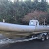
I find the detail on the Garmin 451S fine and rugged enough too - it's mounted in a quite exposed position no problems, with liberal squirts of water repellent etc on the connectors.

I mainly use it for hazard avoidance, rather than navigation as I know the area. If people were wanting to see their whole panned route and the different islands etc, then a larger screen may be helpful, but then it depends how much you want to pay for that.

Also the 451s interfaces fine with my Standard Horizon fixed VHF radio and the Advansea AIS TR-200 transponder.

That said, I still carry hard copy chartlets (printed on waterproof paper) that I download from Free charts and pilotage

Here's some more information in case you are new to the area (apologies if not) and for anyone else who maybe thinking of visiting:

The Admiralty Tidal Stream Atlas NP209. Orkney and Shetland is also really helpful, due to the strength of the tides we routinely have here, and because in some places slack tide does not necessarily equate to low or high tide, even when only a couple of miles from the tide data station. For example, the other day I was on one island where at low tide in the harbour, the tide was racing past at 7 knots... Slack water was 2 hours later as the tide was coming in. Maybe not a big deal with you have a RIB in terms of speed, but can be critical if wanting to avoid the eddies, standing waves and overfalls you can get here, with tides that at times can be up to 12kts.

Don't let the latter scare you off though - with a bit of planning and preparation you'll be fine.

Another really useful document for up here is the Clyde Cruising Club's North & North East Scotland and Orkney Islands guide Clyde Cruising Club which is really helpful for both safety and facilities. Well worth the approx £25.

Finally, get a copy of Orkney Harbours Port Handbook - free online here http://www.orkneyharbours.com/pdfs/P...ok-2010-V4.pdf and in hard copy from the Harbour Offices at Scapa: Orkney Islands Council, Marine Services | OIC Marine Services . This is also a great website for the weather forecast, details of visiting cruise ships etc.

While that's a lot more than just about the Garmin Chart plotter, all the above will be a real help if you are coming up here, both for planning and as a backup in case of GPS failure etc.

Do also be aware that there are a fair few areas of no/very poor coverage for mobile phones and VHF marine radio; I thus carry a PLB too so that at least a distress signal can be picked up by a satellite system.

Hope this helps

Best wishes

Steve
__________________
Copinsay is offline   Reply With Quote
Reply


Posting Rules
You may not post new threads
You may not post replies
You may not post attachments
You may not edit your posts

BB code is On
Smilies are On
[IMG] code is On
HTML code is Off
Trackbacks are Off
Pingbacks are Off
Refbacks are Off


All times are GMT. The time now is 23:24.


Powered by vBulletin® Version 3.8.8 Beta 1
Copyright ©2000 - 2024, vBulletin Solutions, Inc.