|
|
 24 September 2012, 22:31
|
#21
|
|
Member
Country: UK - N Ireland
Town: Rostrevor
Boat name: Ricochet
Make: Redbay
Length: 7m +
Engine: Twin F115 Yams
MMSI: 235083269
Join Date: Oct 2011
Posts: 930
|
Quote:
Originally Posted by vjmehra

but I thought there was some kind of high speed chart plotting exercise on the course, have I imagined that!
|
No you did not imagine that - passage making at planing speeds especially at night is at the core of the RYA Advanced Powerboat Course.
Extract from syllabus
Can:
•
Organise the navigation, safety and welfare of the crew during a powerboat passage
•
Navigate at higher speed using time/distance
•
Use electronic navigational equipment for planning and undertaking a passage, including the use of waypoints, routes and XTE, SOG, COG, BTW, DTW
__________________
Maximum Preparation - Maximum Fun
|

|

|
|
24 September 2012, 22:42
|
#22
|
|
Member
Country: UK - England
Town: London
Length: 4m +
Join Date: May 2011
Posts: 266
|
Okay cool, so those that have done the course, did your instructor give you laminated charts to use?
I'm now a member of visitmyharbour.com, so can download and laminate my own for some practice!
__________________
|
|
|
|
|
24 September 2012, 22:53
|
#23
|
|
Member
Country: UK - England
Town: London
Length: 4m +
Join Date: May 2011
Posts: 266
|
On myharbour, I've signed up, logged in and activated my account, yet all the charts are still watermarked, any idea how I get rid of these?
__________________
|
|
|
|
|
25 September 2012, 07:45
|
#24
|
|
Member
Country: UK - Scotland
Town: Girvan & Tayvallich
Boat name: Breawatch
Make: Ribcraft
Length: 5m +
Engine: Mercury 150 F/stroke
MMSI: ex directory!!
Join Date: Sep 2008
Posts: 6,203
|
Quote:
|
Originally Posted by vjmehra
On myharbour, I've signed up, logged in and activated my account, yet all the charts are still watermarked, any idea how I get rid of these?
|
Hi don't know what you mean. I have never had any problem but I only use PC mode.
Sent from my iPhone using Rib.net
__________________
jambo
'Carpe Diem'
Member of the ebay Blue RIB cover club
Member of SABS ( Scottish West Division)
|
|
|
|
|
25 September 2012, 11:46
|
#25
|
|
Member
Country: UK - Wales
Town: N Wales Chester
Boat name: Mr Smith
Make: Humber
Length: 6m +
Join Date: Feb 2009
Posts: 5,238
|
We use "Tough Charts". They are a series of charts made for popular areas of the uk. Ours covers NW Wales, Anglesey and the Llyn Peninsula. They don't make them any more I don't think, but pop up on ebay and there are some that are still in stock with suppliers.
I think they did the Solent and other areas too.
Theyare a spiral bound book a bit bigger than A4 and are waterproof as they're a waxy finish. Greath for open ribs and aren't as detailed as full on charts, but show all depths and features.
Have a google. Admiralty Tough Charts, Admiralty Charts | Mailspeed Marine
__________________
|
|
|
|
|
25 September 2012, 12:00
|
#26
|
|
Member
Country: UK - England
Town: Southampton
Make: Ballistic
Length: 7m +
Engine: Yam 225
Join Date: Jun 2010
Posts: 1,003
|
Quote:
Originally Posted by vjmehra
On myharbour, I've signed up, logged in and activated my account, yet all the charts are still watermarked, any idea how I get rid of these?
|
crtl +f5 when in the web browser can sometime help. (refreshes the cache)
__________________
|
|
|
|
|
25 September 2012, 12:06
|
#27
|
|
Member
Country: UK - Wales
Town: Barmouth
Boat name: Blue Marlin
Make: Ribcraft
Length: 7m +
Engine: Yanmar 315/Bravo 2X
MMSI: 235020218
Join Date: Jun 2003
Posts: 827
|
Quote:
Originally Posted by Ribochet
No you did not imagine that - passage making at planing speeds especially at night is at the core of the RYA Advanced Powerboat Course.
|
That's not what was asked - he was asking about chart plotting/passage planning at planing speeds, not passage making at planing speeds.
On my APB we pre-planned the route during the day, had route cards which were laminated (but we had pens/chinagraphs to make any changes), went to Beaumaris for Fish and Chips - and my leg was to nav the Swellies, in the dark, on Low Spring Tide, with timings for 10kts, 15kts and 20kts - keeping to 20 kts as the baseline...... 
The best bit was that the Mrs was driving - and she had to do exactly what she was told, exactly when I told her to do it,  And she did!! Ah, the memories...
We also had the full charts with us in a waterproof bag - so when the next crew ran very shallow off Port Dinorwig, we went into the marina and tied-up, re-planned the leg on the pontoon to take into account the slightly shifted sandbank, and then completed the run back to the start point. I think we all passed... 
__________________
|
|
|
|
|
25 September 2012, 12:12
|
#28
|
|
Member
Country: UK - Wales
Length: no boat
Join Date: Jan 2012
Posts: 1,012
|
Quote:
Originally Posted by vjmehra
On myharbour, I've signed up, logged in and activated my account, yet all the charts are still watermarked, any idea how I get rid of these?
|
By watermark do you mean the "THIS FREE CHART IS NOT FOR NAVIGATION" copyright style/type watermark.
__________________
|
|
|
|
|
25 September 2012, 12:21
|
#29
|
|
Member
Country: UK - England
Town: Cambridgeshire
Boat name: Nimrod II
Make: Aerotec 380
Length: 3m +
Engine: Yam 15 Tohatsu 9.8
Join Date: Nov 2007
Posts: 8,297
|
Similar to several others here I guess I have my Garmin charts on the PC and just print out/laminate areas we are operating in to a scale that suits for emergency use (and write on any notes applicable before laminating).
In my case with sibbing it is a backup to a handheld mapping gps. Never needed them but reassuring to know they're there.
__________________
|
|
|
|
|
25 September 2012, 12:37
|
#30
|
|
Member
Country: UK - England
Town: London
Length: 4m +
Join Date: May 2011
Posts: 266
|
Dragonhawk, yep thats what I mean, do those not dissapear now I've paid for membership?
__________________
|
|
|
|
|
25 September 2012, 12:39
|
#31
|
|
Member
Country: UK - England
Town: Salcombe, Devon, UK
Boat name: BananaShark
Make: BananaShark
Length: 10m +
Engine: 2xYanmar 260 diesels
Join Date: Mar 2003
Posts: 4,225
|
We make custom laminated charts up from the (Navionics) charts on my Ipad - after saving them as photos I can draw extra information on such as CTS, time to next waypoint, course and distance then print and laminate them - the navigator has to cope with speeds up to 70mph but he does have a 14" widescreen display which can also access the engine data - navigation information is fed to the driver that has a pair of Raymarine ST70 displays and the throttleman has the same as the navigator - an E series 140W - probably a bit much for a small RIB! 
Not forgetting a pair of fixed VHF's, AIS etc ..........
__________________
Cookee
Originally Posted by Zippy
When a boat looks that good who needs tubes!!!
|
|
|
|
|
25 September 2012, 12:40
|
#32
|
|
Member
Country: UK - England
Town: London
Length: 4m +
Join Date: May 2011
Posts: 266
|
Ah actually they sent me a mail with a link this morning and it works fine now, either I was using the wrong section or my account wasn't fully activated!
__________________
|
|
|
|
|
25 September 2012, 12:41
|
#33
|
|
Member
Country: UK - England
Town: London
Length: 4m +
Join Date: May 2011
Posts: 266
|
Haha, nice setup Cookee, but yeah maybe overkill for us ;-)
__________________
|
|
|
|
|
25 September 2012, 15:54
|
#34
|
|
Member
Country: UK - Scotland
Town: Girvan & Tayvallich
Boat name: Breawatch
Make: Ribcraft
Length: 5m +
Engine: Mercury 150 F/stroke
MMSI: ex directory!!
Join Date: Sep 2008
Posts: 6,203
|
Quote:
|
Originally Posted by vjmehra
Ah actually they sent me a mail with a link this morning and it works fine now, either I was using the wrong section or my account wasn't fully activated!
|
Glad your sorted. Sorry about this mornings hurried answer but I just never had that problem. No stopping you now. Happy cruising
Sent from my iPhone using Rib.net
__________________
jambo
'Carpe Diem'
Member of the ebay Blue RIB cover club
Member of SABS ( Scottish West Division)
|
|
|
|
|
25 September 2012, 16:09
|
#35
|
|
Member
Country: UK - England
Town: Wickford, Essex
Boat name: Wanderer
Make: Ribeye, Zodiac FR
Length: 7m +
Engine: Yamaha F300, 25 2S
MMSI: 235095667
Join Date: Aug 2010
Posts: 219
|
Chart wise I use admiralty charts as a personal preference. I've found that half an admiralty folio chart is A3 size so I copy, print then laminate on A3. I've done it for A4 sizes but I've found A4 to be a lot less usable.. I tend to keep these charts on the boat unless I'm planning a trip when I'll mark up the charts accordingly.
I've also made up a table template for use when passage planning in case gps signal is lost (and yes it has happened to me on a passage from Eastbourne to burnham on crouch) or if plotter fails etc. I admit I probably go overboard but it has 12 columns (not all are used at each trip) incl
Name of item e.g. NE Maplin
Type e.g. G cone
Characteristics e.g. Fl.g.5s
Waypoint Lat
Waypoint Long
Log miles at waypoint
Dir (M) - course to steer after waypoint
Dist to next waypoint
Current speed
Time to next waypoint
Time waypoint passed
I have the blank template laminated and kept on the boat in case I need it as well as pre-prepared completed sheets (completed when I do my passage planning) which if it is a regular route for me I'll laminate or else print out and keep in a see through sealable plastic wallet. I use Velcro to attach to the console although I guess masking tape would be ok.
When I did my night passage plan for my PB Adv it made it a lot easier.
When it comes to writing on the laminates I've always disliked chinagraph pencils although lots of people swear by them. I use non-permanent OHP pens which once dry are pretty resistant to water and accidental rubbing etc.
That having been said, it's a lot easier using a plotter.
Cheers.
__________________
|
|
|
|
|
25 September 2012, 16:18
|
#36
|
|
Member
Country: UK - Scotland
Boat name: Wildheart
Make: Humber/Delta Seasafe
Length: 5m +
Engine: Merc 60 Clamshell
MMSI: 235068449
Join Date: Apr 2007
Posts: 4,670
|
Quote:
Originally Posted by dnv
To me a chart needs to show a big enough area coz otherwise a Rib has crossed the area shown too quickly, and a small chart does not provide sufficient overview. On the other hand details should be shown. To me A5 is showing too little area or/and too little detail.
|
Hence the flipchart idea. I have them arranged so that most trips will be a next / previous page job (advantage of the lochs in scotland - a lot of the water lends itself to a linear map!), so no faffing looking for page 28.....
Different charts for differnet needs. I cannot keep control of anything bigger than A5 without serious risk of it going over the side. (lost 4 event laminates over the years whilst en route to rescue dinghies)
I guess a bigger rib with a big console & a windscreen A4 or even A2 could be easily managable.
Horses for courses! 
Quote:
Originally Posted by Paul Glatzel
I tend to agree that operating a plotter at higher speeds in rougher conditions can be quite challenging as your hands never seem to do what you want them to – which can actually make it easier to work with a smaller hand held plotter and hand held charts that move as you do.
|
Have a look on the "falkirk wheel" thread - the reason my plotter is mounted where it is- I spent a couple of weeks destroying cardboard boxes to prototype that pod - it is designed to take my gloved hand resting on the side of the pod while I push the buttons with my thumb. Can easily operate it at 25 knots in a reasonable sea (hand is moving at the same speed & direction as the plotter), and if I need the throttle mid muckabout it's right under my hand.
The trick of driving with one eye ahead & one on the screen took a bit of getting used to.....but when seated the plotter is at the perifery of my vision , so a quick glance is usually enough. If I'm standing I'm reading the water anyway so will stop to check the screen if I need to.
__________________
|
|
|
|
|
25 September 2012, 16:25
|
#37
|
|
Member
Country: UK - England
Town: Sheepy Parva
Boat name: Sadly Sold
Length: no boat
Join Date: Sep 2008
Posts: 1,731
|
Quote:
Originally Posted by vjmehra
Haha, nice setup Cookee, but yeah maybe overkill for us ;-)
|
Oh, I don't know. Aim high 
Having been on Cookee's boat, the boat itself/engines/electronics/seats/everything else is definitely something to aspire to
__________________
|
|
|
|
|
25 September 2012, 17:04
|
#38
|
|
Member
Country: UK - N Ireland
Town: Rostrevor
Boat name: Ricochet
Make: Redbay
Length: 7m +
Engine: Twin F115 Yams
MMSI: 235083269
Join Date: Oct 2011
Posts: 930
|
Quote:
Originally Posted by vjmehra
Okay cool, so those that have done the course, did your instructor give you laminated charts to use?
|
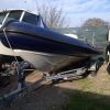
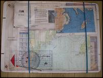
I am a Instructor so on my advanced courses I introduce students to most of the methods discussed on this thread and then let them play around with them to see how they work in practise or not as the case maybe.
Below is my own personal "chart table" with a waterproof chart holder which goes everywhere on my RIB and as such has 1000's of miles under its belt - so it does work - very well
 .
__________________
Maximum Preparation - Maximum Fun
|
|
|
|
|
25 September 2012, 17:40
|
#39
|
|
Member
Country: UK - England
Town: London
Length: 4m +
Join Date: May 2011
Posts: 266
|
Great, thanks for your advice everyone, very helpful!
__________________
|
|
|
|
|
25 September 2012, 17:56
|
#40
|
|
Member
Country: UK - England
Length: 3m +
Join Date: Sep 2008
Posts: 2,762
|
Quote:
Originally Posted by vjmehra
I already do a passage plan beforehand, but I thought there was some kind of high speed chart plotting exercise on the course, have I imagined that!
|
Not done Advanced but my instructor on PB2 was keen that I should and provided lots of examples of what I'd learn / have to do.
He didn't mention plotting at high speed but you could expect on the night exercise for them to turn off the chart plotter part way along the journey and tell you its failed and you need to carry on with out it. They might then tell you that there is a problem with the boat or a crew member and you need to urgently head to a safe haven. That safe haven will not be your original planned destination so you need to be able to quickly re-plan your passage from the chart, having taken bearings to fix a possition etc. A well constructed passage plan should have bail out points so it *should* just be a case of taking your possition and working out the bearing to get the to the planned point of entry for the port and then following the previously planned instructions to get into that port...
__________________
|
|
|
|
|
|
 Posting Rules
|
You may not post new threads
You may not post replies
You may not post attachments
You may not edit your posts
HTML code is Off
|
|
|
|
 Recent Discussions
 |
|
|
|
|
|
|
|
|
|
|
|
|
|
|
|
|
|
|
|
|
|
|
|
|
|
|
|
|
|
|
|
|
|


 Breawatch